
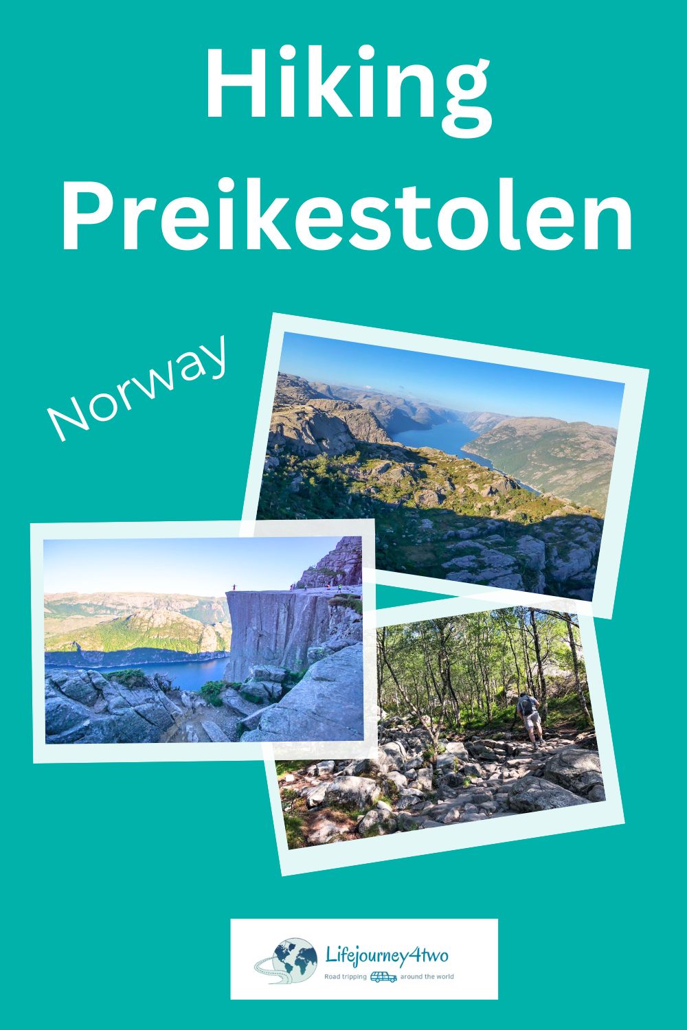
Thinking about your Norway bucket list? There’s so much to explore, but if there’s one hike that tops the list, it’s Preikestolen or Pulpit Rock.
Is Preikestolen worth the hike? Absolutely! The stunning scenery and unforgettable views make this hike a must-do for any adventurer.
Before you start lacing up those boots, let’s review some important points that will influence your decision.
Forget Tom Cruise’s Mission Impossible! We’re here to make your Pulpit Rock hike totally doable with all the tips you need.
Having lived in Norway for years and calling the quaint village of Skudeneshavn home, we’ve experienced many of its iconic and off-the-beaten-path attractions. From cute white-wooden historic buildings and blackened stave churches to phenomenal hikes, ethereal Northern Lights, and stunning scenery, Norway is unforgettable.
No wonder it’s a destination of choice for so many travellers.
🥾 Post Overview: Is it Worth Visiting Preikestolen? 🥾
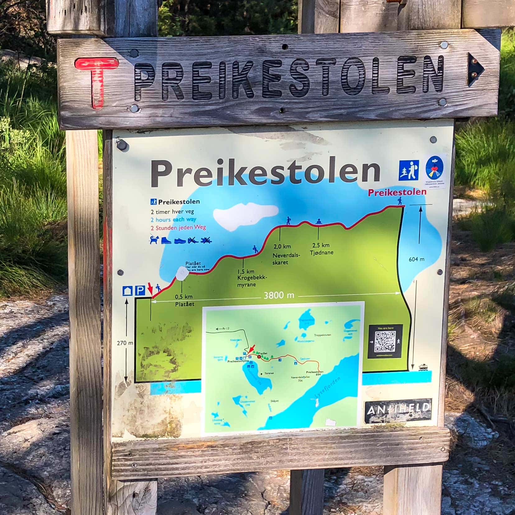
Pulpit Rock Hike Details
- Distance: 7.6 km roundtrip
- Hiking Time: 3 to 5 hours (5 to 6 hours in winter)
- Difficulty: Medium (suitable for average fitness levels)
- Elevation Gain: 350m from the car park to Pulpit RockHiking Season: All year round (guide recommended in winter)
- Hike Markers: The trail is well-marked
- Busiest Months: June to September
- Area of Pulpit Rock: The plateau is roughly 25m x 25m (82ft x 82ft)
- Car Park Cost: NOK 250 per day (pay on exit)
- Toilets: Adjacent to the Preikestolen Mountain Lodge car park (none on the hike)
- Drinking Water: Bring your own
- Summer Tips: Bring sunscreen and a hat
- Sustainability: Certified ‘Sustainable Destination’
- Accessibility from Stavanger: The easiest route is via the Ryfylke Tunnel
- Drones: Illegal near the summit (sign indicates the no-fly zone)
- Safety Tips: Stay hydrated, wear appropriate footwear, and check weather conditions before starting the hike.
- Best Times to Hike: Start early in the morning or later in the afternoon to avoid crowds and enjoy the best lighting for photos.
Planning a Trip to Norway?
- 🚗 Hiring a car? We recommend getting a quote from DiscoverCars
- 🚐 Hiring a campervan? We recommend Motorhome Republic
- ⛑ Arranged your travel insurance? Compare quotes from World Nomads & Safetywing
- 🪪 Order your International Driver’s Licence online here
- 🏩 Booked your accommodation? We use Booking.com to find the best deals
- 🐾 Is someone pet-sitting for you? 🐾 We use and love TrustedHousesitters
- (Get 25% off at checkout for new memberships with our discount code: LIFEJOURNEY25)
Our Preikestolen Adventure
Climbing Pulpit Rock was an adventure we couldn’t miss. We tackled both Kjeragbolten and Preikestolen in one day—ambitious but rewarding! Here’s what we learned:
- Challenges and Rewards: The steep early climb was tough, but the views were worth every step.
- What to Wear: Sturdy hiking boots, layered clothing, and plenty of water are essential.
- Where to Stay: Consider extending your stay in Stavanger for a more relaxed experience.
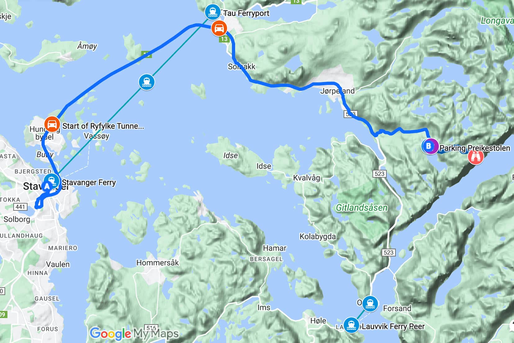
Map: Preikestolen Norway Hiking Route
How to Use This Preikestolen Route Map
- To use this interactive map effectively, click the square icon in the upper right corner to expand.
- A key will appear on the left, guiding you through various locations.
- Clicking on any site reveals detailed information about that spot.
- Blue lines denote the driving route. Purple denotes the ferry routes.
- The Black marker denotes the trailhead.
- Preikestolen (Pulpit Rock) is denoted with a Pink marker.
- Other places we’ve personally visited are also highlighted with distinct location icons.
Our Experience of Hiking Preikestolen
Tackling the hike to Pulpit Rock might seem ambitious, but the reward of magnificent views makes it a challenge worth accepting. Here’s our experience of stepping up to one of Norway’s iconic trails.
Hiking Pulpit Rock: Are We Crazy?
We had our hearts set on climbing the famous Pulpit Rock. This world-renowned hike was a must-do on our list. The long summer days gave us plenty of daylight to tackle these fantastic hikes.
e night before, we wild camped on a nearby mountain within a few kilometres of the Kjerag trailhead to start our day early and avoid the summer crowds.
After conquering Kjeragbolten, a challenging 12-kilometre hike to the ‘bolt in the mountain’, by midday, we were back at our car contemplating the next move. With a good ten hours of daylight left, we decided to hike the iconic Pulpit Rock.
In hindsight, hiking both Kjerag and Preikestolen on the same day was physically demanding. We recommend spreading the hikes over two days.
Commencing the Pulpit Rock Hike
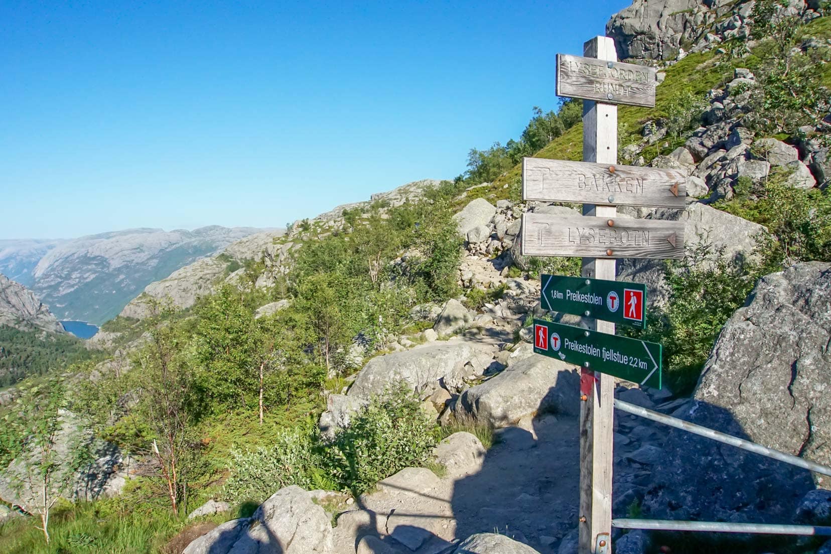
We parked our car at P1, just 100m from the trailhead, and began treading the gravel road towards Preikestolen. The trail is well-marked with directions.
Like other Norwegian hiking trails, the red ‘T’s painted on the rocks guide you in the right direction.

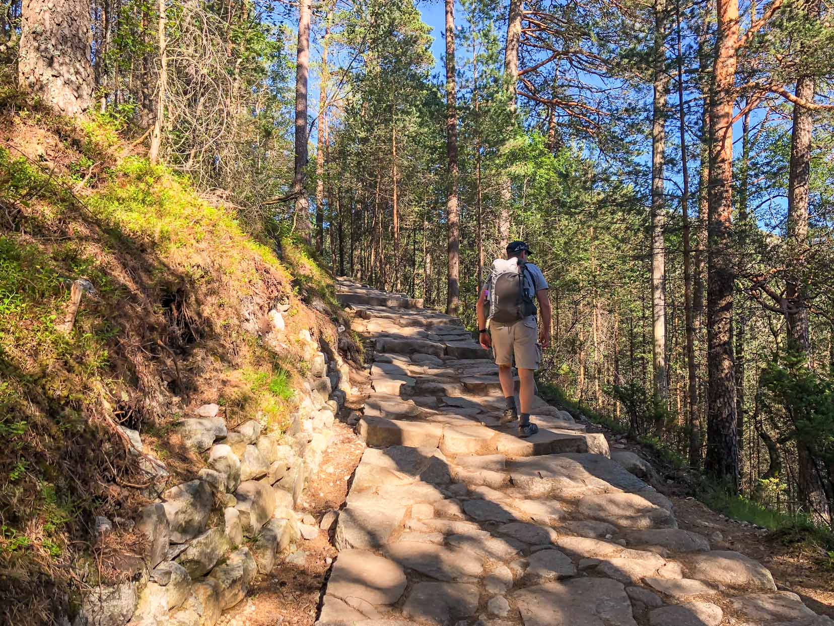
The initial part of the uphill gravel trail meanders through forested scenery with views over the picturesque Lake Revsvatnet before reaching a rocky section. It’s a bit uneven here, so careful foot placement is required.
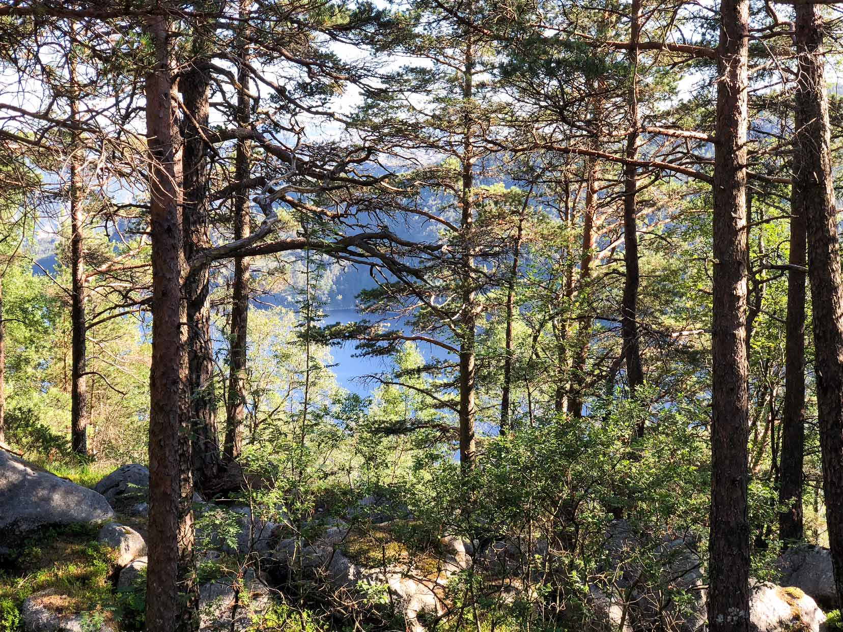
The large squared-off stones, laid by Nepalese Sherpas, mark the uphill path. This early steep climb is the toughest part of the hike; once past it, you can expect more gentle rises.

Midway – Pulpit Rock Hike
The trail soon opens onto a wide expanse of rock. The long, gentle uphill path already had a handful of hikers on it.
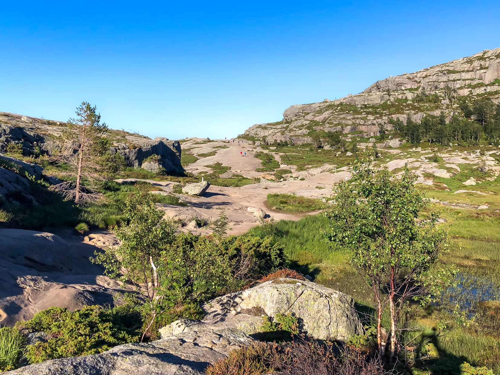
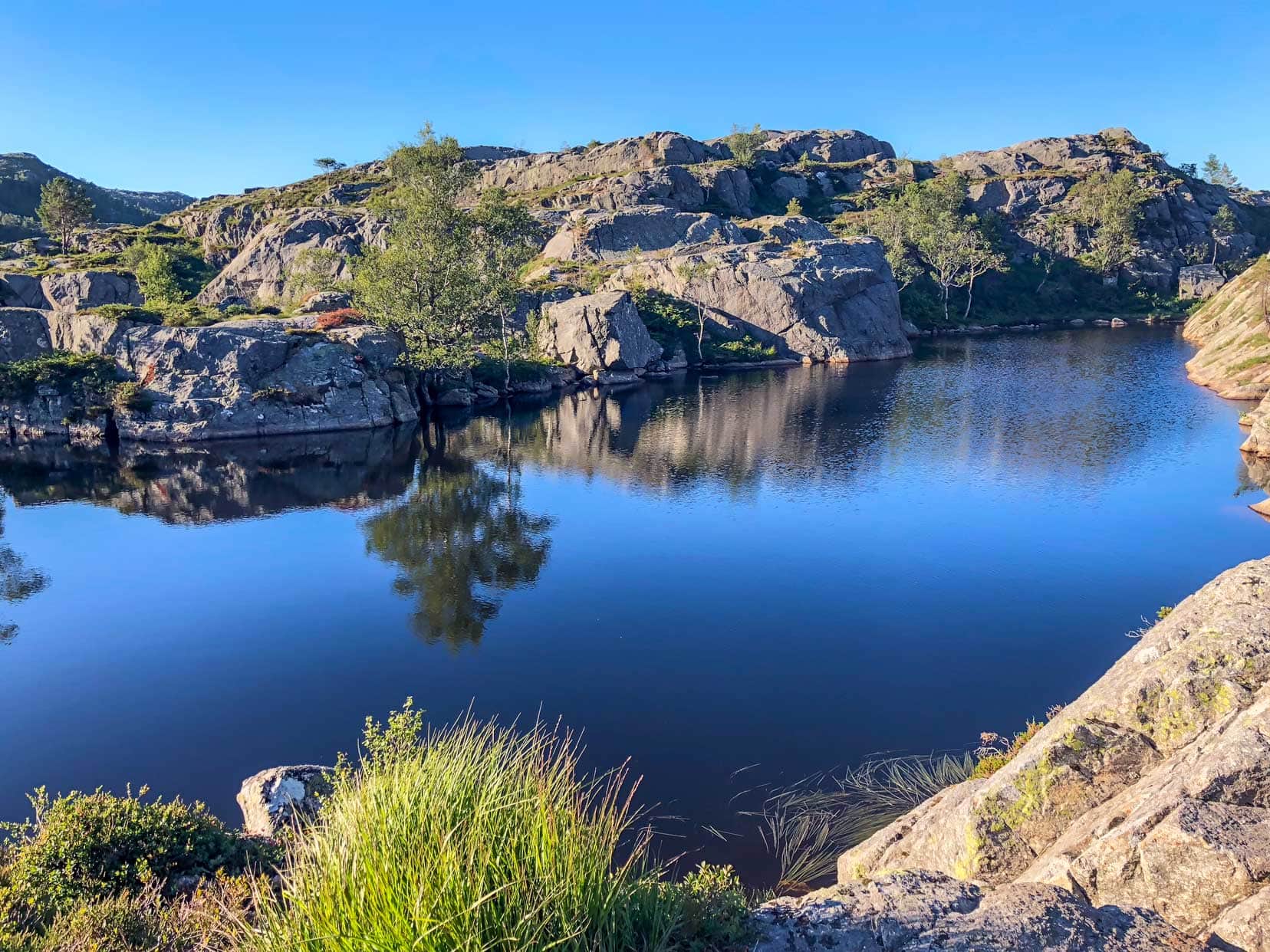
Nearby, the sounds of splashing drew us to a small lake where a couple of hikers had taken a plunge. We pushed on, following the trail markers.
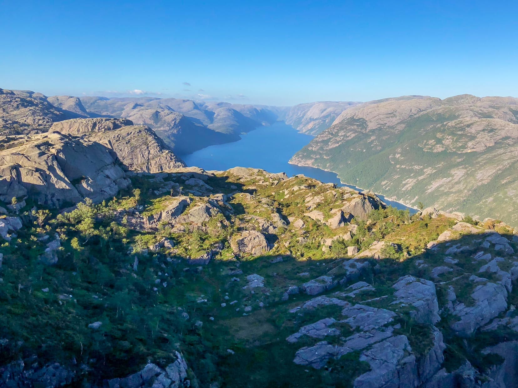
Cresting the rise, the scenery expanded, and we caught our first distant glimpses of Lysefjord. There are plenty of opportunities to stop and take in the expansive views along the way.
Nearing Pulpit Rock Summit
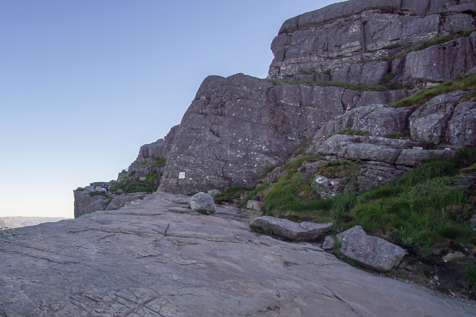
The trail crosses strategically placed wooden pedestrian bridges with chained handrails, passing over difficult terrain. The bridges are designed for single-lane traffic, so you may need to wait for others to cross.


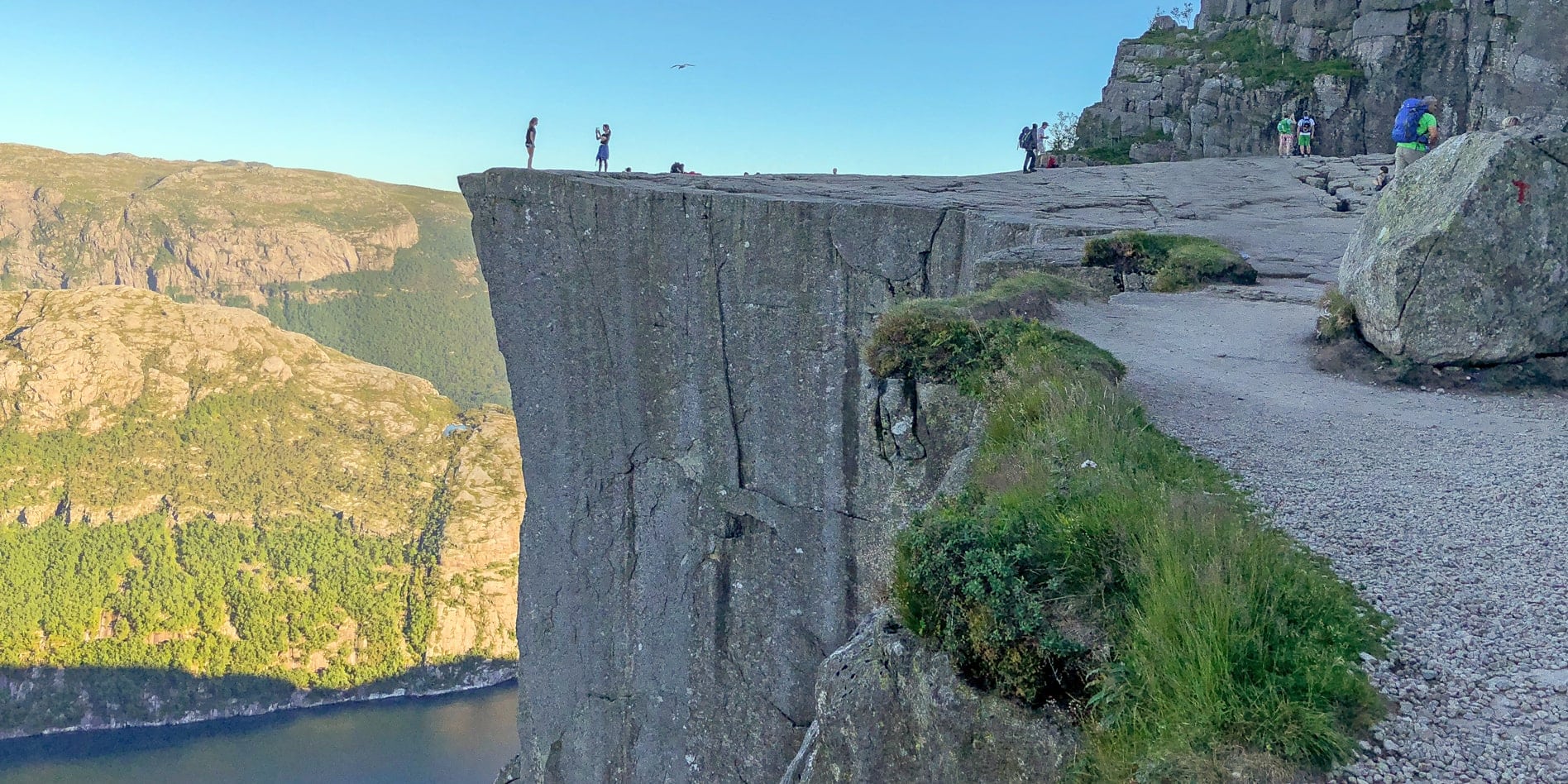
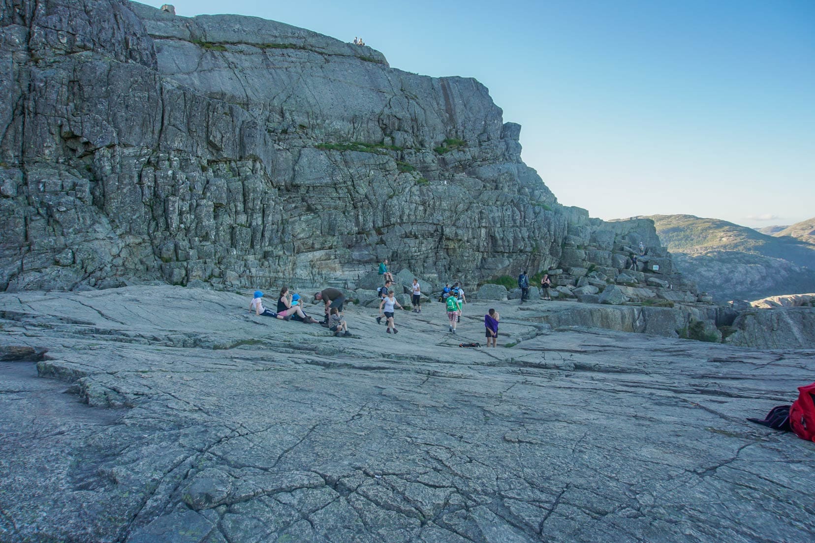
Soon, you find yourself near the rocky ledge of Preikestolen. Following the cliff, the path winds over deep fissures, not large enough to fall through but small enough to trap your foot.
Peering down through the fissure, you can see Lysefjord, 600m below.


Reaching Pulpit Rock: Mission Accomplished
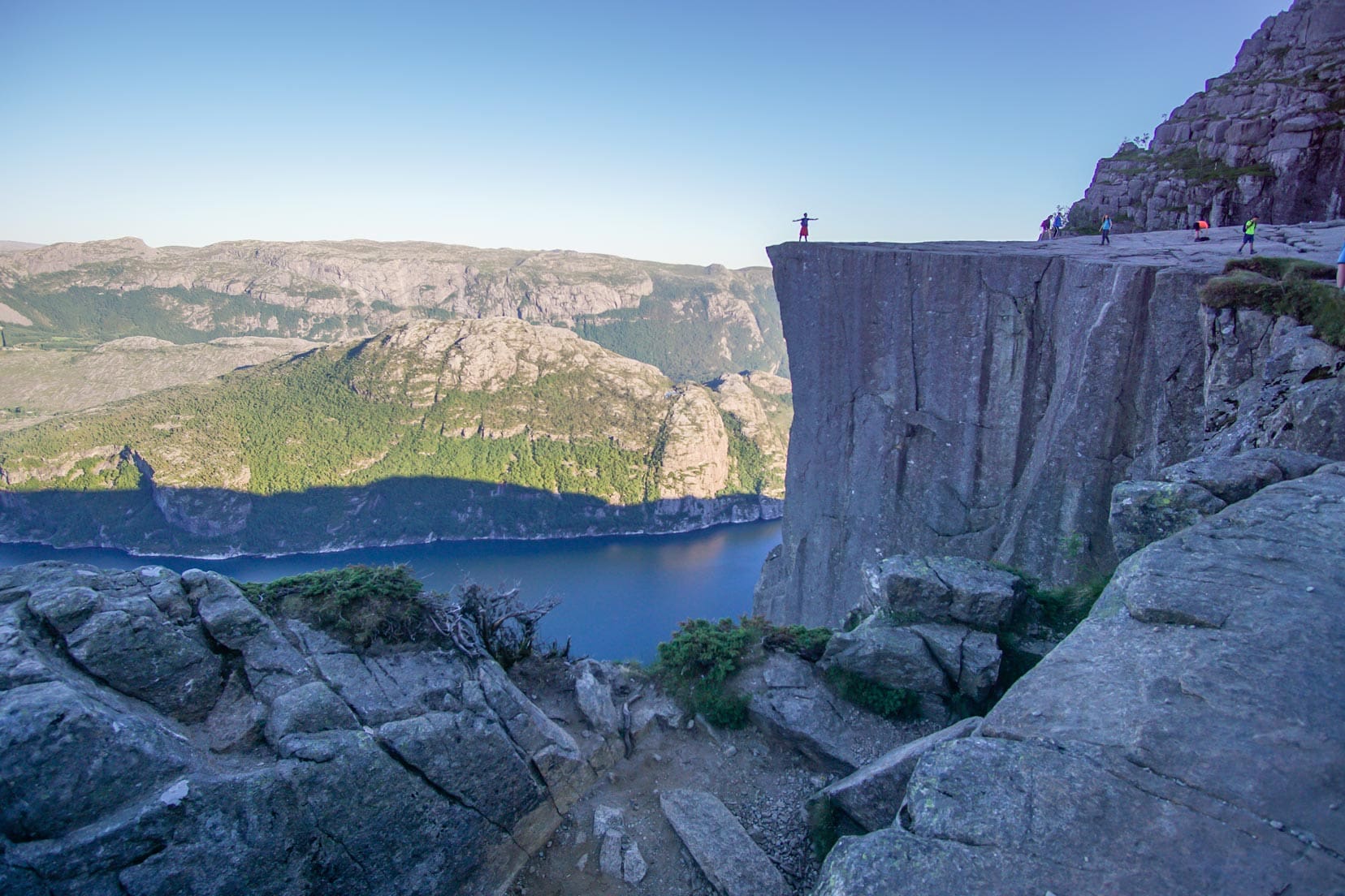
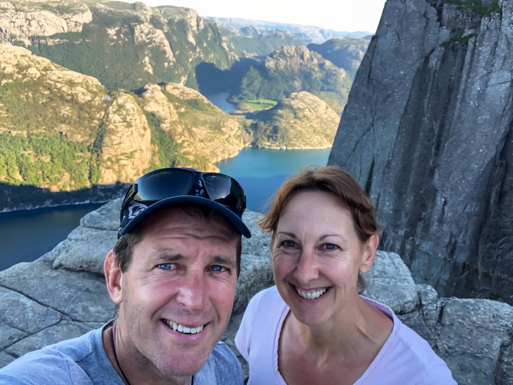
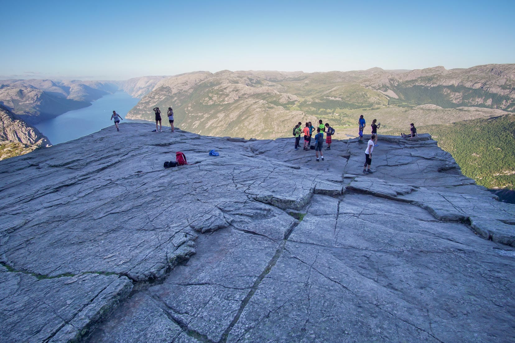
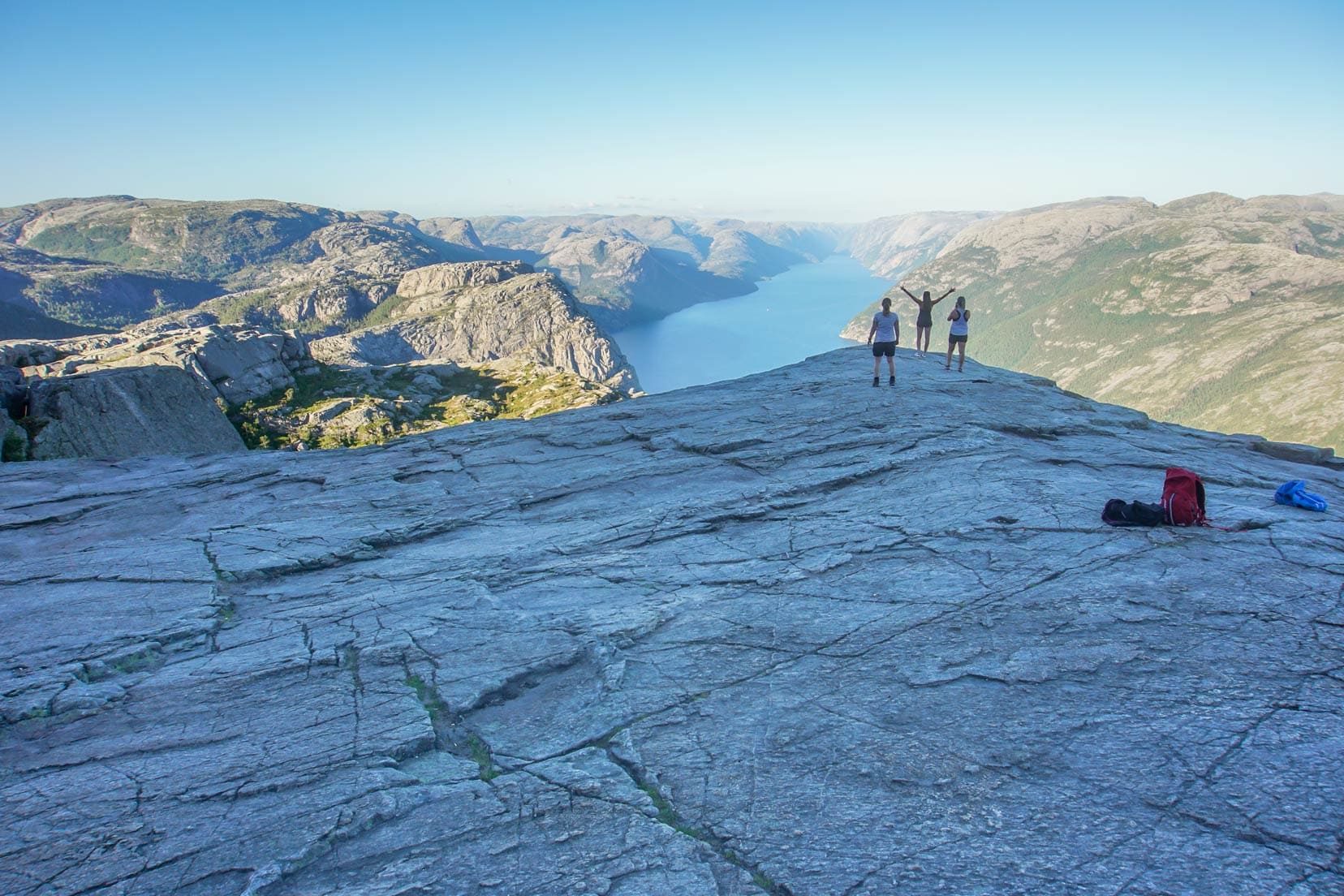
The last 100m of the hike brings Preikestolen into view. This final stretch is perfect for capturing iconic photos. Be cautious, as there are no barriers to prevent a fall.
We arrived at 8:15 pm and found fewer than a dozen people on the plateau. Pulpit Rock, pointing east, was already in deep shadow, so it wasn’t the best for photos, but the views were still stunning!
Depending on the experience you want at the top, it may be better to time your arrival when Preikestolen is sunlit.
Regardless, the hike was picturesque, and seeing this impressive feat of nature earned us bragging rights. Before us lay a phenomenal landscape of grey craggy cliffs plunging into a crystalline blue fjord—a quintessential Norway picture-postcard view.
Yes, visiting Preikestolen was absolutely worth it.
Given the 600m sheer drop to the Lysefjord below, approach the edge with utmost caution. It is advisable not to run or attempt stunts; if you wish to look over the edge, do so by lying on your stomach.

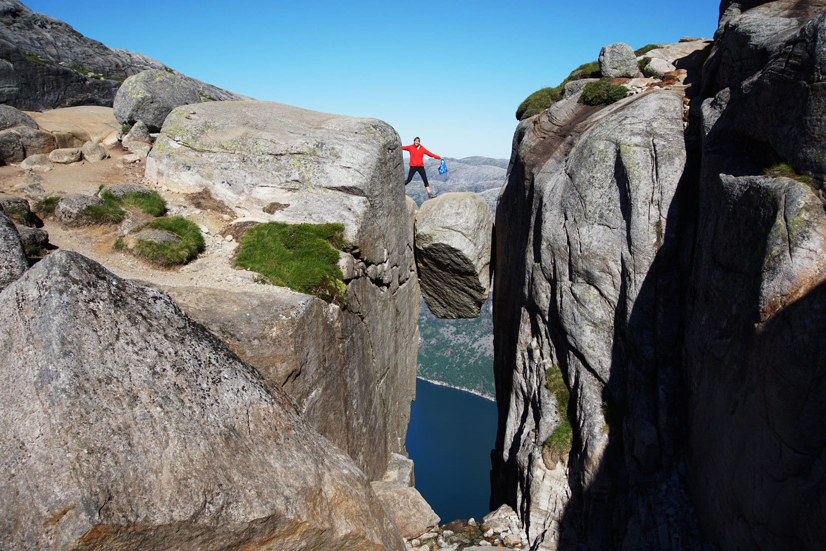
For even better views, climb the rise behind Preikestolen and venture even further away. You can see in the photo where the hikers have pitched their tents.


Descent from Pulpit Rock
The steps impacted our knees, so we took a few breaks on the way back. The descent gave us another chance to soak up the incredible scenery in the late afternoon light.
Preparation to Hike Preikestolen
Proper preparation is crucial for a successful hike to Preikestolen.
Fitness Level
This 7.6 km roundtrip hike with a 550m elevation gain is rated as ‘Medium’ difficulty according to Norway’s hiking standards, meaning it’s suitable for those with average fitness and some experience walking in varied terrain.
Under ‘Medium’ difficulty, you’ll need average fitness and some experience walking in varied terrain. Expect elevation gains of no more than 600m and trail lengths up to 10km. Most people should meet this requirement.
Trail Condition
The hike starts with a steep ascent before levelling out to more gentle rises. Some sections are unstable, especially when wet or snow-covered, making summer hiking generally easier than winter. The last few hundred meters before reaching Preikestolen parallel the precipice, requiring careful supervision of young children as there are no barriers.
On the descent, walking down the final section of hand-crafted granite steps can jar the knees. Using walking sticks may help.
Despite these hazards, you can have peace of mind knowing that Sherpas have been instrumental in improving accessibility to Preikestolen, making the trail safer and the hike more enjoyable for everyone.
Best Time to Visit Preikestolen
Preikestolen offers a unique hiking experience in every season. Use the Norwegian app yr.no for accurate weather forecasts to plan your hike.
Here’s what to expect in each season:
Summer Hike (June to August): This is the busiest time of the year, but it offers the best chance for clear weather. The trail is free of snow. To avoid the crowds, start your hike early in the morning or later in the afternoon.
Autumn Hike (September to November): With fewer visitors, this season allows for a more personal experience at Preikestolen. Keep in mind that the days grow shorter during this period.
Winter Hike (December to January): Hiking times generally extend to 5-6 hours. While hiking without a guide is possible, it is not advised due to the challenging conditions.
Spring Hike (March to May): Expect snow-covered trails that gradually reveal spring’s growth. The days start to lengthen, giving you more daylight for your hike.
Preikestolen (aka Pulpit Rock): The Early Days
This flat section of rock, shaped during the last ice age over 10,000 years ago, covers an area of roughly 25m x 25m with a sheer drop of 604m to Lysefjord, a 42-kilometre-long fjord.
Pulpit Rock was discovered in 1896 and was noted for its resemblance to a preacher’s pulpit. The first tourist visited Preikestolen in the early 1900s.
Today, it draws more than 300,000 visitors per year.
From 2013 to 2018, Sherpas improved the trail’s quality and safety.
In 2020, Preikestolen was certified as one of Norway’s Scenic Hikes and a sustainable destination. This certification means that the not-for-profit organisation overseeing Preikestolen continues to reduce the negative impact of tourism on this popular Norwegian landmark.

What to Wear When You Hike Preikestolen
The weather in Norway is variable year-round, with winter temperatures plunging below zero. Snowfall is common during late autumn, winter, and early spring.
Preparation is key to having a good experience at Preikestolen.
At a minimum, you should wear or pack:
- Sturdy hiking footwear
- Woollen socks (extra pair for winter)
- Breathable layers
- Waterproof jacket and trousers
- Head covering (beanie or hat, gloves, depending on the season)
- Water and snacks
- A backpack to carry items and keep your hands free
- Sunglasses
- Phone for communication
How To Get To Preikestolen
Most visitors start their journey to Preikestolen from Stavanger, which is conveniently located just 40 km away.
By Tunnel and Road
The quickest and easiest route to Preikestolen is via the Ryfylke Tunnel, accessible by self-driving or taking an express bus. The Ryfylke Tunnel is notable for being the world’s longest and deepest subsea road tunnel for vehicles. Costs vary depending on your mode of transportation:
Self-drive
The tunnel toll for vehicles under 3 tonnes on a return trip is NOK 358. An automatic toll system is in place, and vehicles without an Auto-PASS tag must register for an account to manage toll invoices.
Preikestolen parking costs NOK 250 per day (overnight parking is not permitted), and there are about 1,000 spaces available. If the parking lot is full, vehicles will be directed to an Overflow Waiting Zone. Self-driving offers the most schedule flexibility.
Express bus:
Return trips from Stavanger cost around NOK 480, with six hours allocated between pick-up and drop-off. Pre-booking is essential. One-way tickets are available for those who wish to stay overnight and return the next day. This service is for transport only, not a guided tour.
Looking for a guided hike? This hike has great reviews and departs Stavanger for Preikestolen.
🥾 Book this Guided Hike to Preikestolen | ⭐️⭐️⭐️⭐️⭐️ 5/5 Star Reviews |
⏰ 9 hours
By Ferry and Road
Stavanger to Tau Ferry
This 25-minute ferry ride costs NOK 264 for a return trip. Continue on Rv13 via Jørpeland to Preikestolen. The ferry operates on Mondays, Wednesdays, Fridays, and Sundays. Ferry Schedules
Lauvvik to Oanes Ferry:
Drive from Stavanger to Lauvvik and take a short ride to Oanes, then drive to Preikestolen Parking. Costs are NOK 145 per car under 5 meters, plus NOK 50 per passenger. Ferry Info and Booking
Hire a Car or Motorhome
🚘 We use Discovercars.com to find the best car rental deals.
If you are looking for a motorhome or campervan rental, we highly recommend Motorhome Republic, which finds the best deals worldwide.
Is It Worth Visiting Preikestolen? The Pros and Cons Uncovered
Each season brings its unique charm to Preikestolen, making it a worthwhile destination year-round. To ensure you’re well-prepared, check the weather using reliable sources like the Norwegian app, yr.no.
Pros:
- Accessibility: Just 40 km from the major city of Stavanger.
- Travel Convenience: Easy and quick access via the Ryfylke Tunnel by car or express bus.
- Manageable Difficulty: The hike is of moderate difficulty, suitable for most people with average fitness.
- Duration: Only requires a half-day, making it ideal for a quick adventure.
- Year-Round Access: Open throughout the year, each season offering a different hiking experience.
- Accommodations: Available at the trailhead, ranging from lodges to campsites.
- Less Crowded Off-Season: Quieter during the winter and shoulder seasons.
- Facilities: Well-equipped trailhead with amenities including a café.
Cons:
- Crowds in Summer: Can become quite busy, detracting from the peaceful nature experience.
- Longer Duration in Winter: Snowy conditions can extend the hiking time; using a guide is advisable.
- Not Suitable for Young Children in Winter: The challenging conditions make it less safe for young hikers.
- Lack of Facilities on the Trail: Prepare for self-sufficiency during your hike.
- Afternoon Shade: This can impact photography since the rock faces east and is shadowed later in the day.
Where to Stay
Here are some comfortable and budget-friendly accommodation options.
Preikestolen Base Camp

Stavanger Accommodation

Wild Camp
As mentioned, we wild camped in the Norwegian mountains, which is a fantastic experience and absolutely legal under Norway’s ‘right to roam’ law.
Frequently Asked Questions
Is it Worth Visiting Pulpit Rock?
Absolutely! Pulpit Rock is worth visiting. The dedicated hiking trail is accessible to people of average fitness levels. From Stavanger, it’s just a short 45-minute drive to the Preikestolen car park.
How Long Does it Take To Walk Up Preikestolen?
The round-trip hike from the car park takes 3 to 5 hours in summer and 5 to 6 hours in winter.
When Can You Hike Pulpit Rock?
You can hike Preikestolen year-round. In summer, the trail is snow-free and is the most popular time to visit. In winter, there are fewer hikers, but snow makes it advisable to have a guide.
Has Anyone Ever Fallen Off Preikestolen?
Unfortunately, there have been incidents. In February 2000, a young couple jumped off Pulpit Rock in a suicide pact. In 2013, a Spanish tourist fell while taking photographs. The Norwegian government does not sensationalise these stories.
Is It Worth Visiting Preikestolen … That’s A Wrap
Is Preikestolen worth visiting? Without a doubt. This hike is not just about the destination but the journey through Norway’s breathtaking landscapes and serene environment.
From the meticulously maintained trails to the sustainable tourism efforts, every detail at Preikestolen is crafted to enhance your hiking experience.
Whether you’re an experienced hiker seeking a new challenge or a casual walker eager for stunning views, Preikestolen accommodates all. Its moderate difficulty level and year-round accessibility make it an adventure that’s both thrilling and achievable.
Every step on this hike promises spectacular vistas, culminating in the iconic flat-top plateau that offers a dramatic view over Lysefjord. It’s a sight that will stay with you long after the hike is over.
While summer months can bring crowds, the off-peak seasons offer a quieter, more intimate experience. The natural beauty, coupled with the sense of accomplishment and the memories you’ll create, make this hike truly special.
So, to answer the lingering question: yes, Preikestolen is absolutely worth visiting. It’s an adventure that blends natural beauty with a rewarding challenge.
Have you hiked the mighty Preikestolen, or are you planning to? We’d love to hear about your plans or experiences in the comments below!
🇳🇴 More Information for Your Trip to Norway
Looking to explore more of Norway? Check out our Norway Travel Guide for detailed information on the best hikes, cultural experiences, city explorations, and extensive itineraries to help you plan your perfect Norwegian adventure.
If you enjoyed the post – why not pin and save it for later?
Planning Your Travels?
These are the travel resources we recommend and use when planning our trips.
- 🚘 Car Hire: We use DiscoverCars.com
- Motorhome/Campervan Rental: We highly recommend the Motorhome Republic
- 🪪 Order your International Driver’s Licence online here
- ✈️ Flights: Find flights on Skyscanner
- 🛏 Book Accommodation: We use Booking.com to find accommodation that suits our budget
- 🐶 Pet Sitting/Pet Sitters: Check Out TrustedHousesitters here (Use our Discount code: LIFEJOURNEY25 for 25% off. )
- Activities and Experiences: Get Your Guide and Viator
- Travel Insurance: Safetywing or World Nomads
- 🥾 Travel Gear and Accessories: Check out our top picks here — Lifejourney4two page on Amazon
For a more thorough list, visit our Travel Resources page here.
My wife and I want to do the hike, but we only have 6 hours in port on a Viking cruise. Is there a way to get it done and be back to the ship in only 6 hours? Thanks!!
Hi David, 6 hours is cutting it fine but it is doable. I don’t know your ages or fitness levels however the hike is geared towards all ages. The return trip drive, from downtown Stavanger to Preikestolen car park, takes 1.5 hours. This leaves you 4.5 hours for the hike. We took roughly 3.5 hours in total starting the hike from the car park including 30 mins at the top to take it all in.
Hope that gives you a better idea of timings. Enjoy. Lars.
I walked up pulpits rock as a 6 year old when I lived in Norway. I still remember it vividly and it was 36 years ago! I remembered the crevasses in the rock and steep drop to the left near the top walking up and set about googling this memory. Your post confirms I remembered these bits correctly. Thankyou for your photos and posts, it brings back how scared I was, but how amazing the view was!
Thanks so much for your comment Jen, isn’t it amazing how we can remember things so clearly – especially when we’ve been scared of something. We’re pleased that our photos were able to confirm your memories of Pulpit Rock and totally agree about the amazing view.
You are going to find life very boring when you return!
When we finally go home we’ll travel around Australia ?? – that will keep the boredom at bay! ?
Okay I’m going to live vicariously through your beautiful photos. I did this hike at the end of April and the visibility was zero, I couldn’t see the edge of Pulpit Rock when I was standing on it haha! There was even snow on top of the mountain and that lovely lake was frozen.
However the hike is great, I can’t believe you did 2 in 1 day! It was a bit slippy near the top when I went which was scary because of the lack of barriers but I can understand they do not want to spoil the natural beauty of the place. I’ll have to go back and try again one summer.
What a shame you hiked all that way and the weather was so unkind! It would have been unnerving being slippy at the top – there were a few quite narrow bits there! Yes, I still can’t believe we did the two hikes in one day … the sun must have gotten to our heads?!
Toujours intéressant de te lire Michelle. C’est vraiment magnifique. Bravo pour les photos !
Merci beaucoup Patricia. Je suis heureux que vous ayez aimé le lire?
Wow, Norway looks absolutely incredible!!
Jessie
Your Story Matters
Thanks, Jessie, it is pretty amazing – such fantastic scenery.
Fabulous guys just love reading all about your amazing adventures …keep them coming.Have fun and take care! Certainly a wonderful world we live in. ?
Thanks so much Leesa, the world is indeed wonderful and so varied! There is so much to see and experience. So pleased you are loving our blogs, we enjoy sharing our travels and have fun writing them (and teasing each other over whose photos are best! ;)) Take care xx
Great post! I just love following all of your adventures. These photos are fabulous and I can only imagine what it is like to experience all of the amazing things you do everyday.
It’s so lovely to hear you enjoy following our adventures. Hopefully, you can get inspiration on what you’d like to experience and put it on your ‘To Do’ list ;).
Looks so so beautiful, love the photos! Norway is such a stunning country xx
Alys
Thanks Alys, We agree, Norway is so beautiful. We have been really blessed with the weather too, one of the warmest Summers in a long time apparently. Have you been to Norway?
Yes I have! I’ve been to Oslo and Ålesund 🙂
Wonderful – what was your favourite place? We hear Geraingerfjord is beautiful ( but all seem to be beautiful! ;). We are thinking of driving North before we leave here, did you enjoy Alesund?
I loved Alesund! My dad had a work thing there so I just went along with him and explored whilst he was working haha
Thanks Alys – we’ll put it on our list! x