
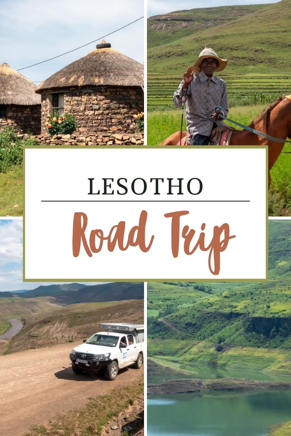
Join us on this Lesotho road trip following part of the iconic Roof of Africa Scenic Route, winding through the Maluti and Drakensberg mountain ranges. We tackled this 3-day route in our 4×4 Hilux, starting on the paved A1 and continuing on the less-travelled A25 to the Sani Pass summit.
Even if you don’t have a 4×4, there’s an alternative route along the A1 that’s perfect for non-4×4 cars, allowing everyone to enjoy the stunning beauty of Lesotho.
I’ve provided 4 different route options along with our 3-day Lesotho itinerary to help you design the best road trip for you.
This adventure begins west at the Caledenspoort Border Control, passing through Katse Dam, and concludes east atop the majestic Sani Pass. If your schedule allows, consider extending your journey to complete the Roof of Africa circular route.
This loop offers more opportunities to explore the breathtaking landscapes and rugged trails that define Lesotho. You’ll likely re-enter South Africa at the Caledenspoort Border Control.
With over 30,000 square kilometres of wild, untamed countryside, Lesotho remains an accessible yet thoroughly off-the-beaten-path destination. It’s the ideal backdrop for a road trip, offering phenomenal views and a profound connection with nature, whether navigating in a 4×4 or cruising in a standard car.
This road trip is part of our larger 4×4 adventure through Southern Africa, showcasing the beauty of this continent.
Route Summary: Our Road Trip Across Lesotho
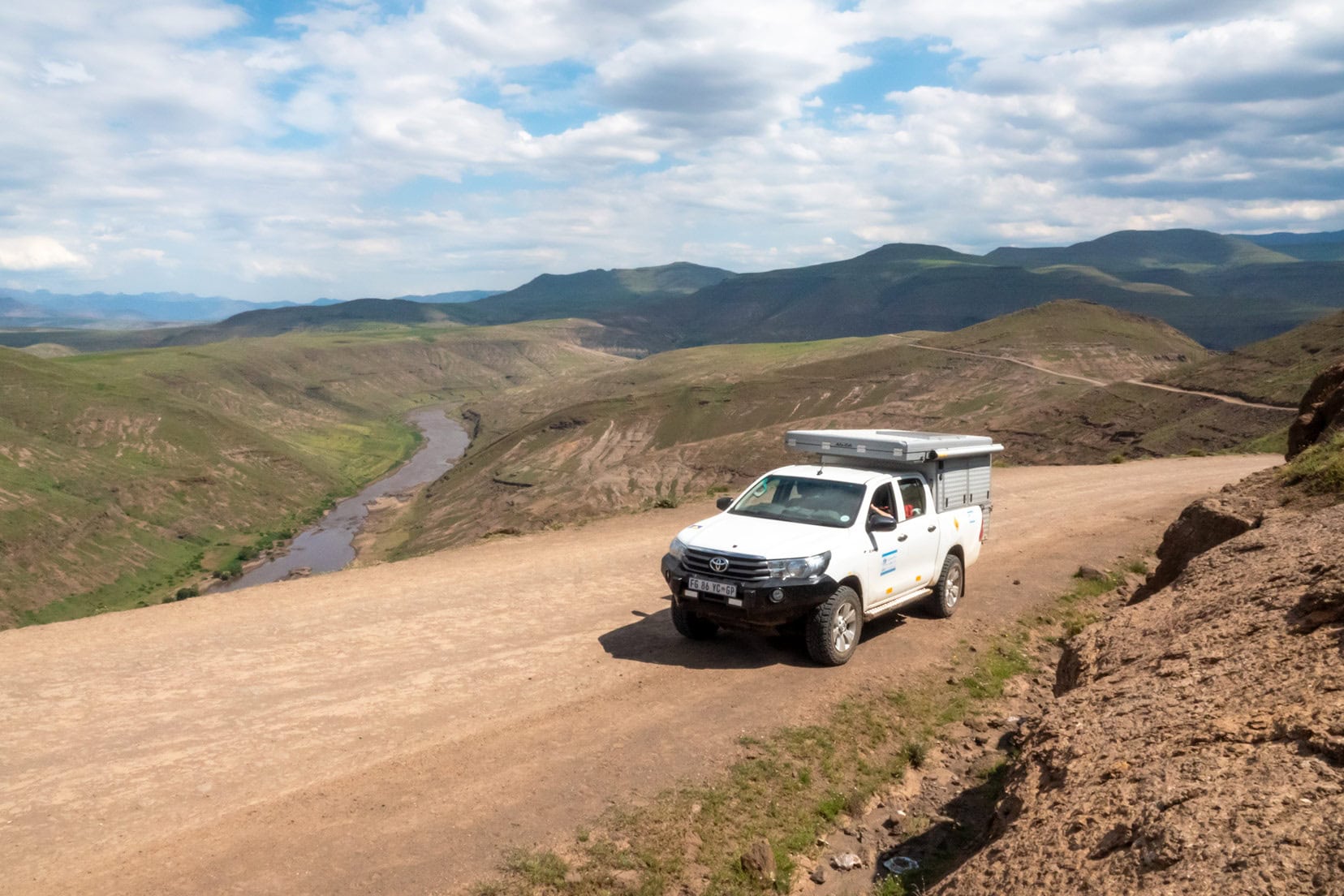
- Journey Details: We spent two days in February exploring Lesotho, starting at Caledenspoort Border Control, passing by Katse Dam, and exiting via the iconic Sani Pass in South Africa. We were driving our own South African registered Toyota Hilux.
- Campsites: Katse Lodge camping, Sani Tops Backpackers Campsite
- Best Time to Visit: The optimal months for travel are between September and April to avoid snow on the roads.
- Traffic Conditions: Vehicular traffic is sparse, with most traffic comprising locals walking, herding animals, or riding horses. Occasional sightings of yellow taxis are also possible.
- Supplies: We stocked up on diesel and food in South Africa, eliminating the need for replenishment in Lesotho.
- Road Experience: Our route included the tarred A1, the gravel A25 to Katse Dam, and the 4×4 road from Katse Lodge to Thaba-Tseka to rejoin the A1, providing a comprehensive experience of this less-travelled destination.
- Local Interactions: The Basotho people were notably friendly, often smiling and waving back. The children were particularly delighted with the chalk, stickers, and ‘bonbons’ we distributed.
- Sani Pass Drive: Only a 4×4 vehicle is allowed to drive the Sani Pass.
Planning a Trip to Lesotho?
- 🚗 Hiring a car? We recommend getting a quote from DiscoverCars
- 🚐 Hiring a campervan? We recommend Motorhome Republic
- ⛑ Arranged your travel insurance? Compare quotes from World Nomads & Safetywing
- 🪪 Order your International Driver’s Licence online here
- 🏩 Booked your accommodation? We use Booking.com to find the best deals
- 🐾 Is someone pet-sitting for you? 🐾 We use and love TrustedHousesitters
- (Get 25% off at checkout for new memberships with our discount code: LIFEJOURNEY25)
Map: Lesotho Road Trip
How To Enter Lesotho: What You Need to Know
- You will need a valid passport and sufficient funds to enter Lesotho
- Most countries are issued a Visa on arrival for a maximum period of 14 days; however, to be sure you can check eligibility here.
- Vodacom Lesotho is the preferred mobile network. It does not support the Vodacom South Africa network, so you must buy a local SIM card for network access. The easiest way to find out where to buy a local SIM is to ask one of the locals.
- It’s easiest to stock up on food, fuel and cooking gas in South Africa before beginning your Lesotho road trip.
- There is a high poverty rate in Lesotho. Having something small at hand to offer the children is a kind gesture. We had colourful chalk, stickers and the favourite, ‘bonbons’.
- Lesotho’s road conditions: The main sealed roads are in good condition; however, be wary of potholes and rocks.
- We navigate Africa with both our digital and hard copy Tracks4Africa maps, which include helpful information such as the type of road surface and realistic travel times between locations.
- If you know South Africa’s road rules, then the same rules apply in Lesotho.
- Entering Lesotho from the West, these are the closest border control points you’ll want to consider:
- Caledonspoort (opening times: 06:00 a.m. to 10:00 p.m.)
- Peka Bridge (opening times: 08:00 a.m. to 04:00 p.m.)
- Ficksberg Bridge (opening times: 06:00 a.m. to 10:00 p.m.)
- Maseru Bridge (opening times: 24 hours)
- Exiting east: Sani Pass border control: (opening time: 0800 a.m. to 4.00 p.m.). Note: the Sani Pass border gate will close in bad weather. You can confirm border control opening times here.
Lesotho Road Trip Options – With or Without a 4×4
There are a few options for a Lesotho road trip which includes visiting Katse Dam, each depending on your destination. I will refer to our driving route in the options presented.
Note: these images below are taken from Google Maps which do not provide true driving times. We rely on our Tracks4Africa maps for accurate timings.
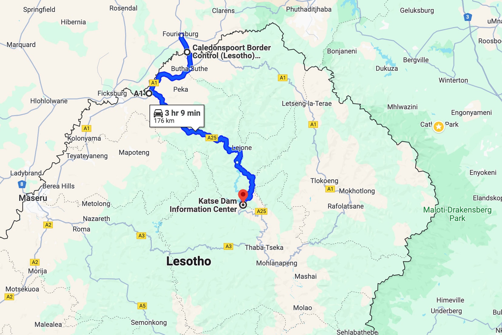
Option 1: Without a 4×4, Drive to Katse Dam and Return on a Paved Road (total distance, 350 km)
- Enter Lesotho at Caledonspoort border control on Likila Road.
- Follow Likila Road 9.1km to the junction with A1. Turn south for 37.5km to the junction with A25 and turn east.
- Follow A25 for 120km to Katse Dam Information Center
- Overnight at Katse Lodge
- Return on the same route to Caledonspoort border control
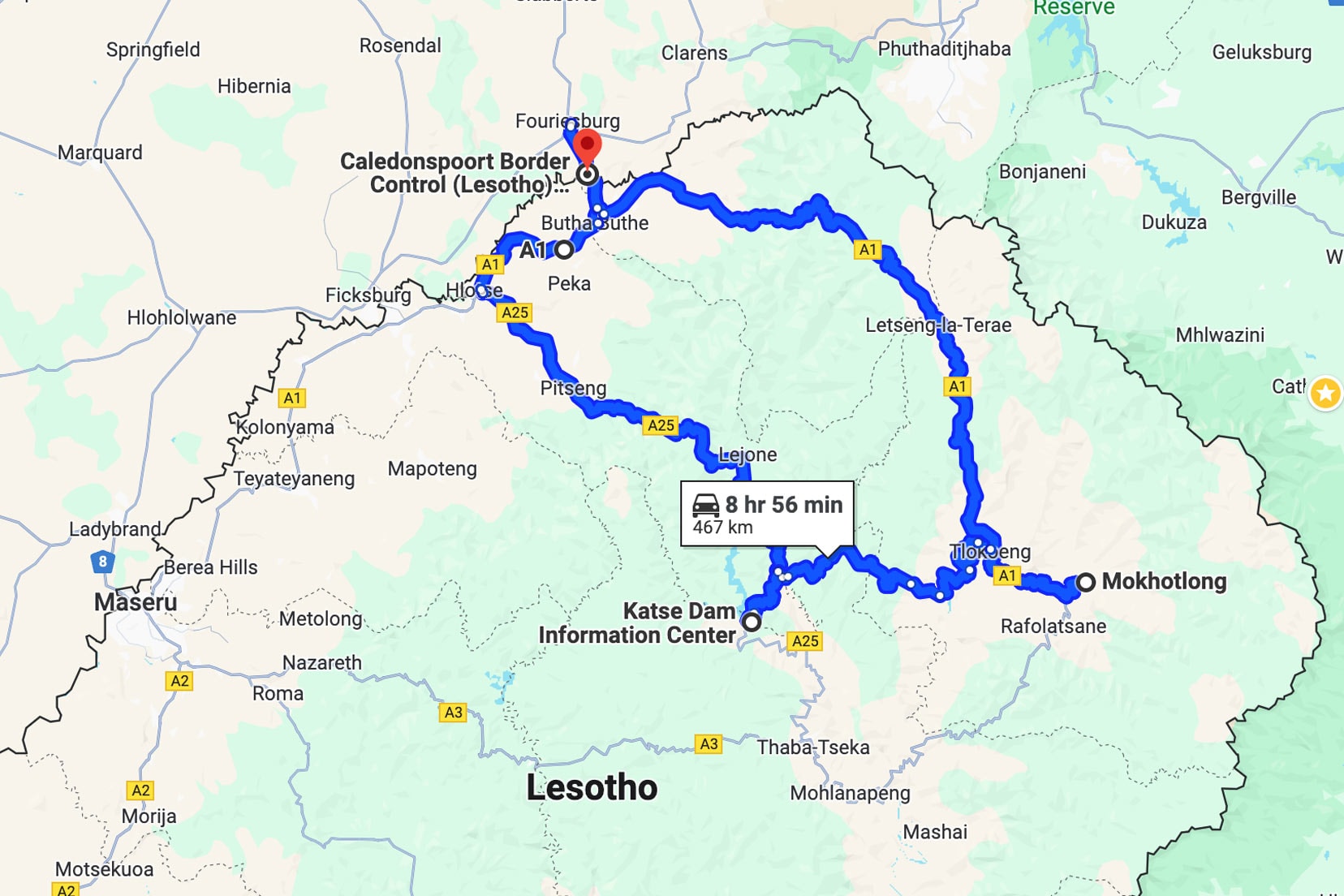
Option 2: Roof of Africa Scenic Route: With a 4×4, Drive to Katse Dam and Return Via Mokhotlong Junction (total distance, 470 km)
- Enter Lesotho at Caledonspoort border control on Likila Road.
- Follow Likila Road 9.1km to the junction with A1. Turn south for 37.5km to the junction with A25 and turn east.
- Follow A25 for 120km to the Katse Dam Information Center
- Overnight at Katse Lodge (if planned)
- Follow A25 south for 61km to the junction of A3, where you turn south to Thaba-Tseka. The road is unpaved.
- The 105km from Thaba-Tseka to Mokholtong junction road requires a 4×4. At the Mokhotlong junction, turn west onto the A1.
- Drive 174km to return to the Caledonspoort border control.
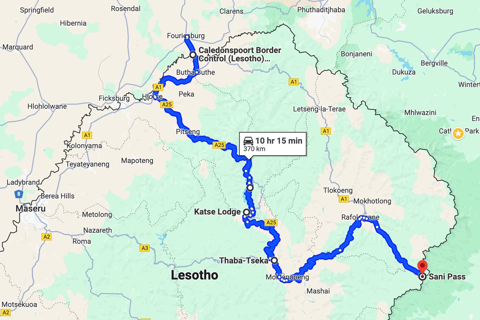
Option 3: Our Route – With a 4×4, Drive to Katse Dam, Mokhotlong Junction and Sani Pass Summit (total distance, 370 km)
- Enter Lesotho at Caledonspoort border control on Likila Road.
- Follow Likila Road 9.1km to the junction with A1. Turn south for 37.5km to the junction with A25 and turn east.
- Follow A25 for 120km to the Katse Dam Information Center
- Overnight at Katse Lodge (if planned)
- Follow A25 south to the junction of A3 and turn south to Thaba-Tseka. The road is unpaved.
- Thaba-Tseka to Mokholtong junction road is 105km and requires a 4×4.
- Turn east onto the A1 at the Mokhotlong junction and drive 51km to Sani Pass.
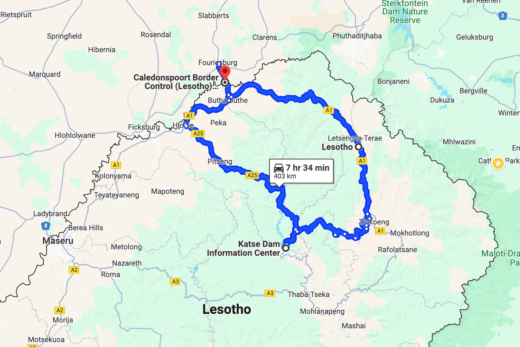
Option 4: With a 4×4, Drive to Katse Dam, Mokhotlong Junction and Sani Pass Summit (total distance, 403 km)
- Enter Lesotho at Caledonspoort border control on Likila Road.
- Follow Likila Road 9.1km to the junction with A1. Turn north and drive 120km to the junction of Kao Mine. The road is unpaved.
- Drive 130km to the Katse Dam Information Centre. I do not know the condition of this road.
- Return to Caledonspoort border control via the paved A25 and drive 120km to the junction of the A1.
- Turn north on the A1 for 37.5km to the junction of Likila Road and drive the 9.1km to Caledonspoort border control.
Need help to get going? Read our article: Road Trip Tips and Travel Planning

Video Teaser: Days 1 & 2
This eight minutes of GoPro footage is played at (x4) normal speed to give you an epic taster of Lesotho.
Our Experience: Lesotho Road Trip Itinerary
We followed route option 3 to road trip over three days through Lesotho. He’s our account of the journey.
Day 1 Itinerary: Caledonspoort to Katse Dam Lesotho
Passing Immigration
Arriving at Caledonspoort Border Control, roughly 10km from Fouriesburg in South Africa, we were stamped out of South Africa. A few hundred metres separates the border control of South Africa and Lesotho.

Entering Lesotho was a fuss-free process.
After showing our passports, entry stamps were added. We were asked about our estimated Lesotho exit date and our intended border control exit point. The date information was added to the entry stamps.
A small toll fee of LSL 40 Loti or equivalent South African Rand, ZAR 40, was paid, and within 10 minutes, we were driving into Lesotho.
Onwards to Katse Dam
About 7km later, keeping to the tarred road, we drove through our first township of Butha Buthe, where we joined the A1 going south-west towards Maseru.
At the township of Hlotse, we swung south onto the tarred A25 and headed east towards Katse Dam.
Up to this point, we had passed plenty of small villages with locals doing their daily business. You know, the usual hustle and bustle of towns.
Yellow-signed mini-van taxis were weaving on and off the road, passengers onboarding and alighting.
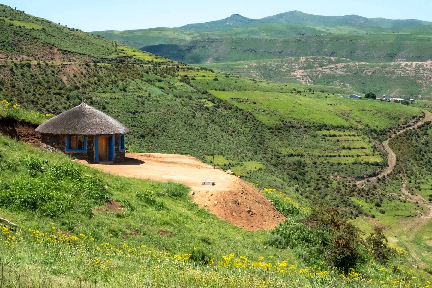
With Hlotse disappearing behind us, green rolling fields soon led to mountains and near-treeless slopes.
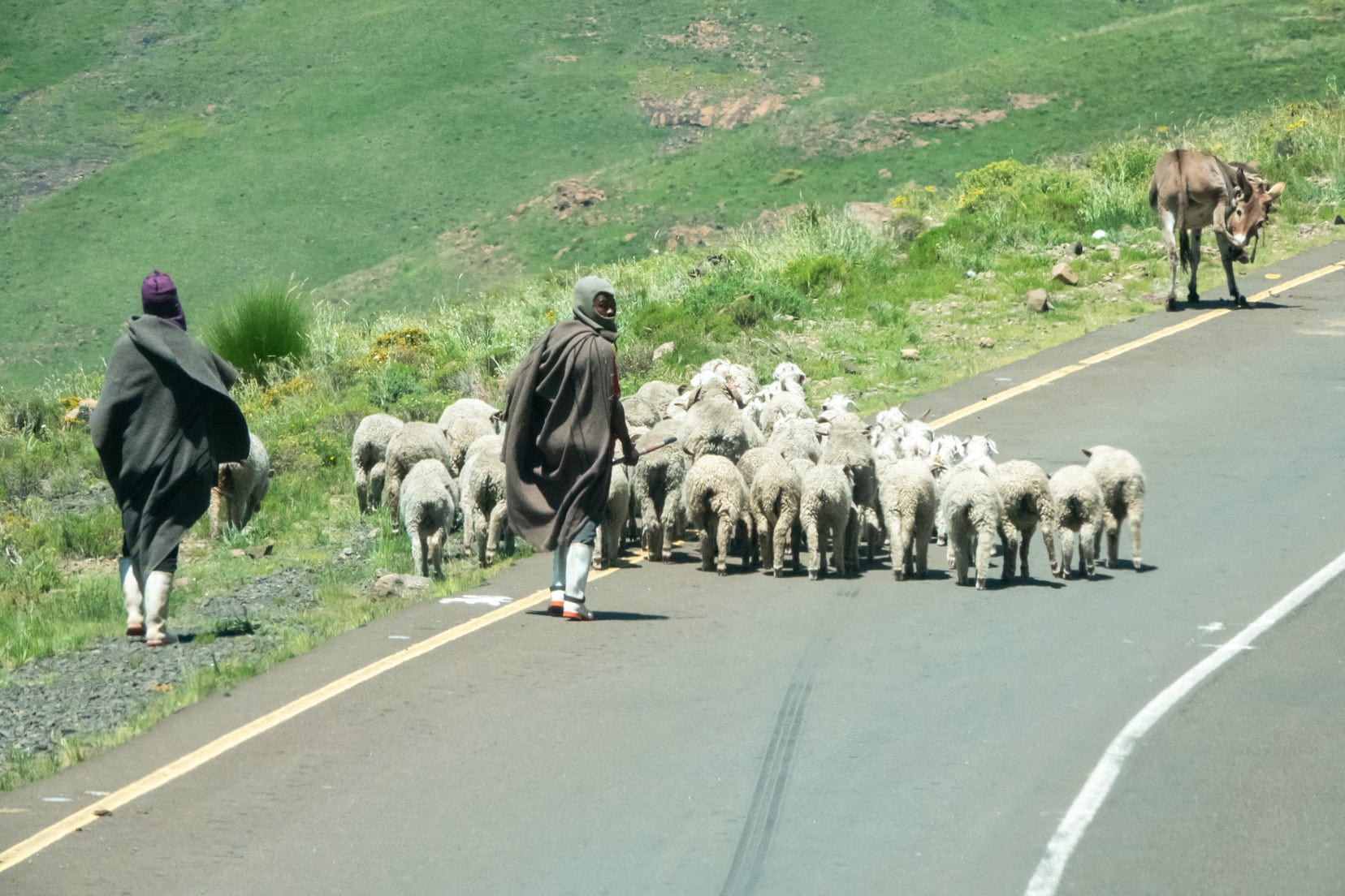
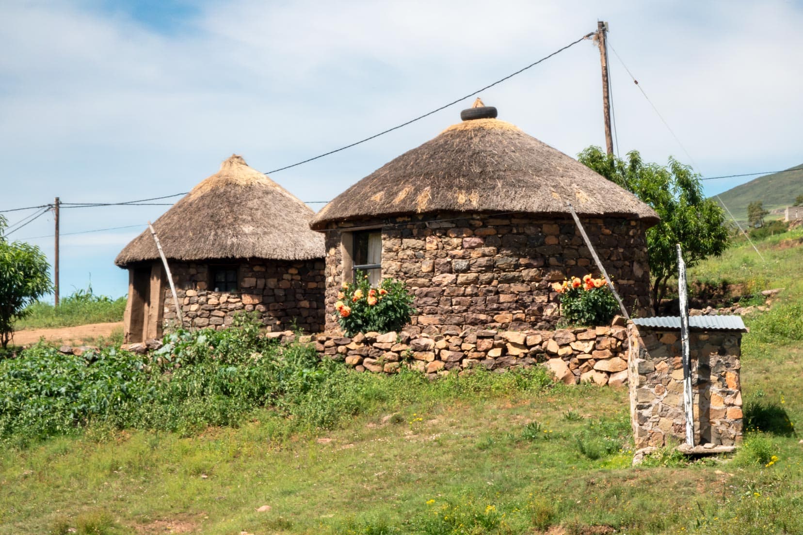
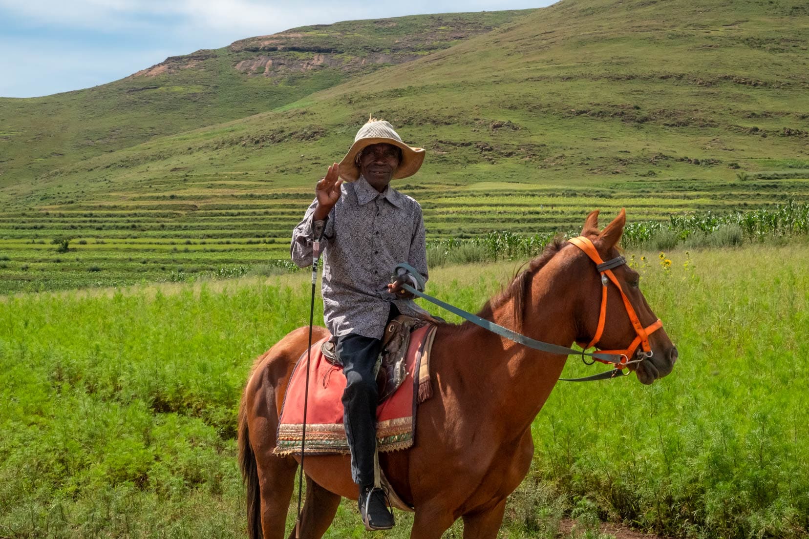
The road was tarred and in good condition. The most common mode of transport we saw was horseback, and it made sense once we saw the many small villages clinging to the steep slopes, which a vehicle would find difficult to reach.
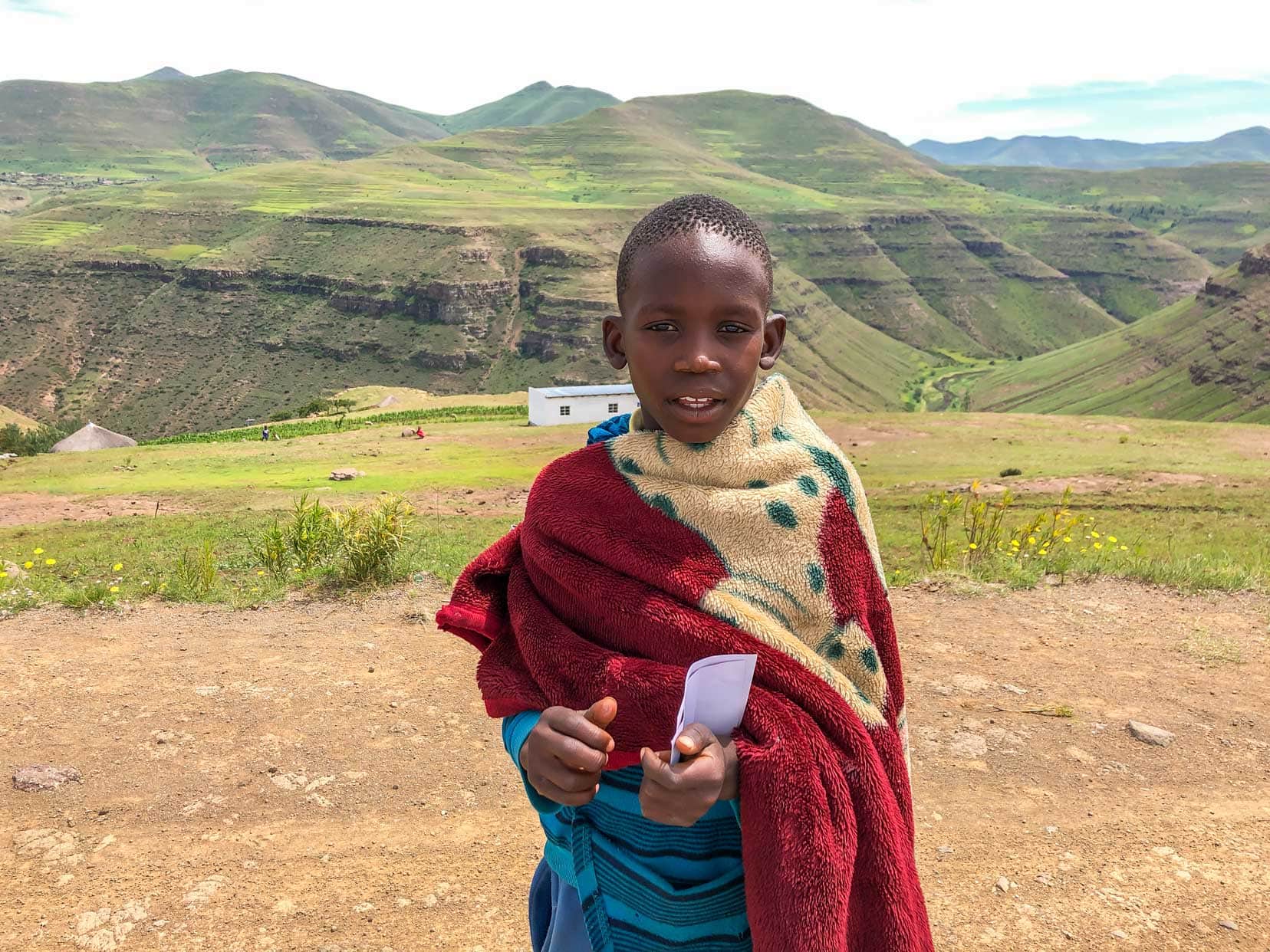
We started sharing the road with shepherds, all males, who were moving their cattle and sheep between fields. The Basotho shepherds’ typical dress code was a thick grey woollen blanket covering their body, a woollen cap and a pair of white gumboots.
As we got closer, we slowed as the men attempted to usher their animals off the road. They were reasonably friendly and waved back.
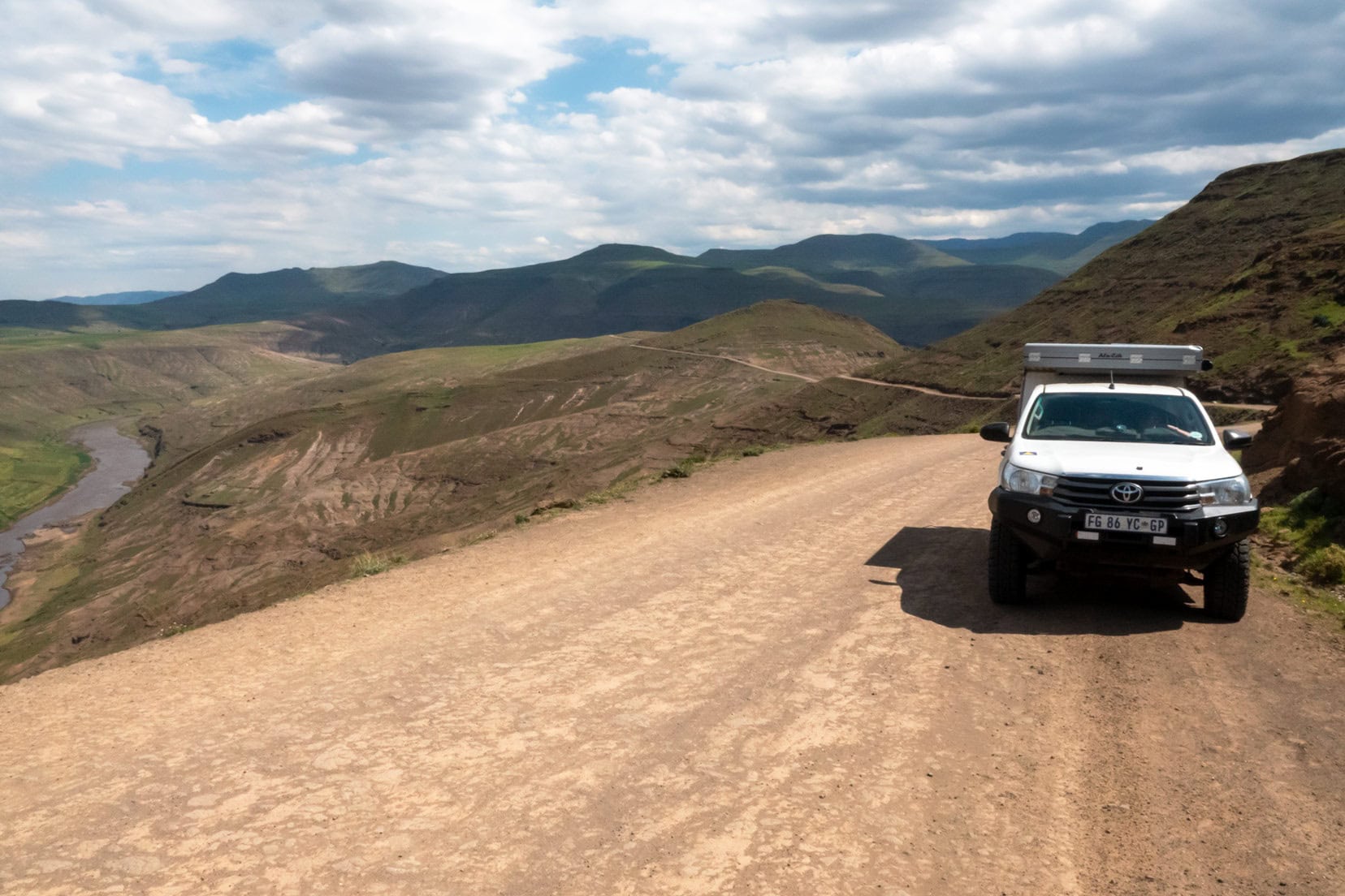
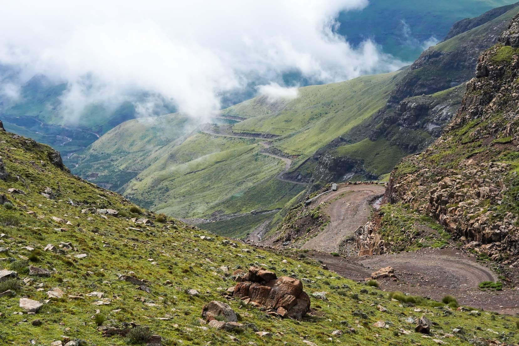
Mafika Lisiu Pass
Still on the A25, the flat fields soon yielded to overlapping mountain slopes as the road began to ascend. Ahead, the Mafika Lisiu Pass rose above us at an altitude of 3240m.
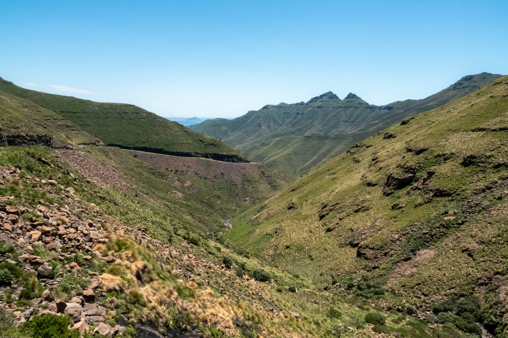
The climb is quite steep, with many winding sections. A word of warning: rocks fall from the slopes above and scatter across the road. We had to swerve around a few, but on the ascent, your speed is slow.
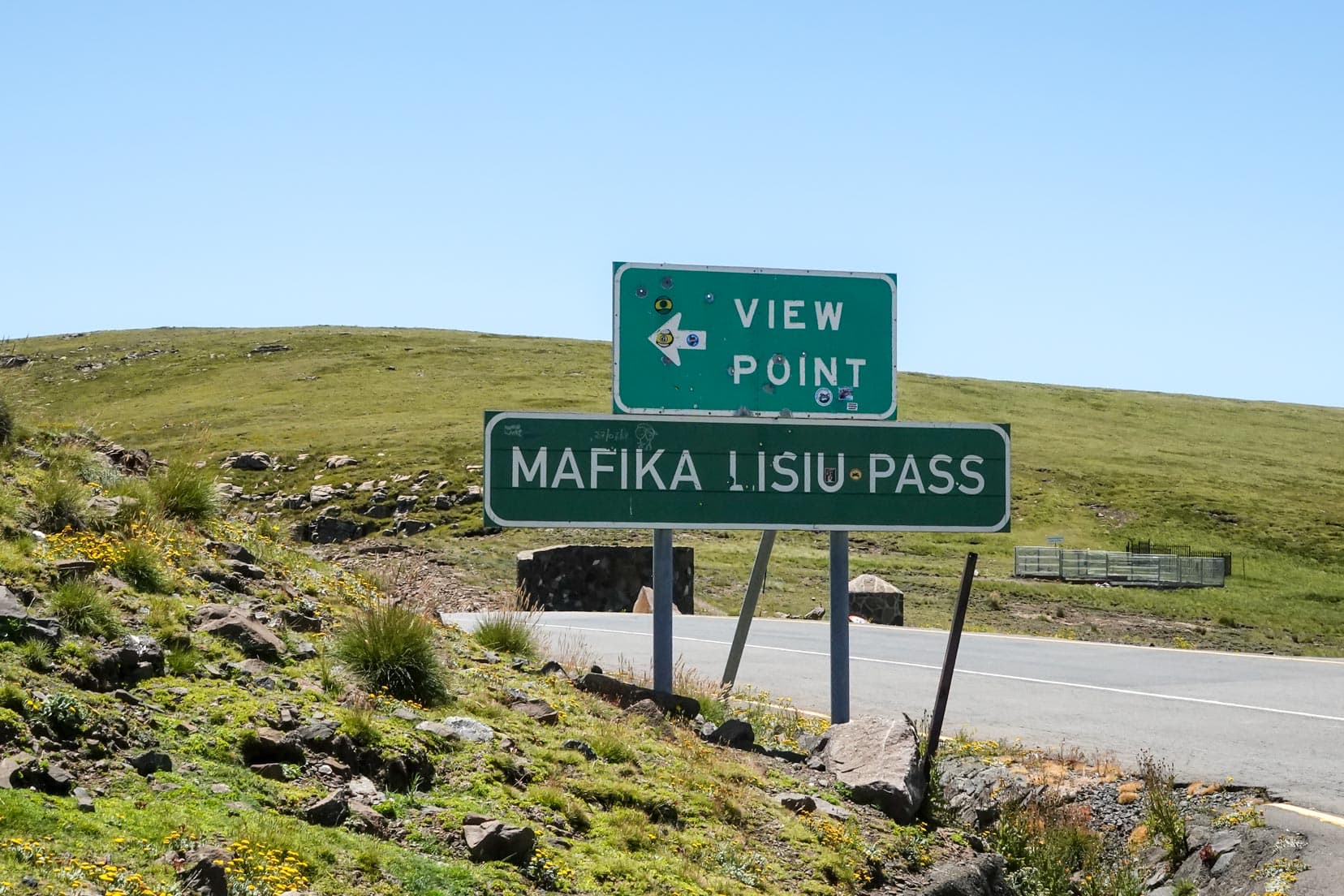
When you reach the summit, turn off the road following the sign to Mafika Lisiu Pass viewpoint. Here, you can overlook the Pass and have great views.
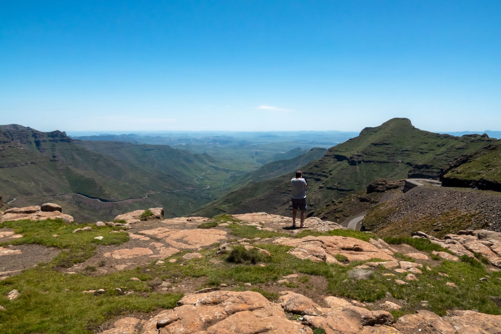
While we were at the lookout, two rival baboon troops started making threatening screeches at each other. It sounded menacing, and Shelley was spooked; she bolted for the car as the group fights broke out.
Baboons were running every which way. As it turned out, this was the only ground-dwelling wildlife we would see in Lesotho.
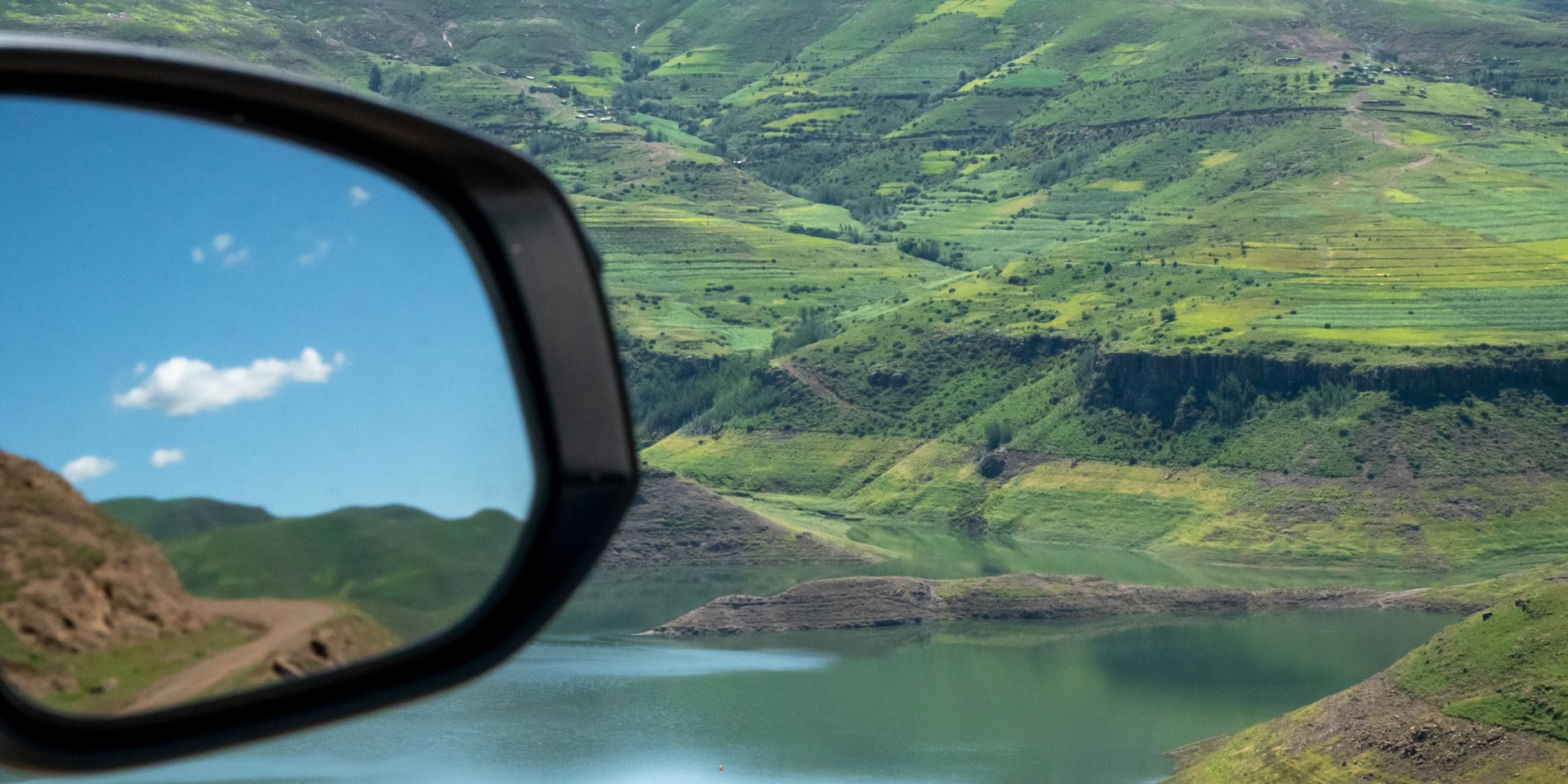
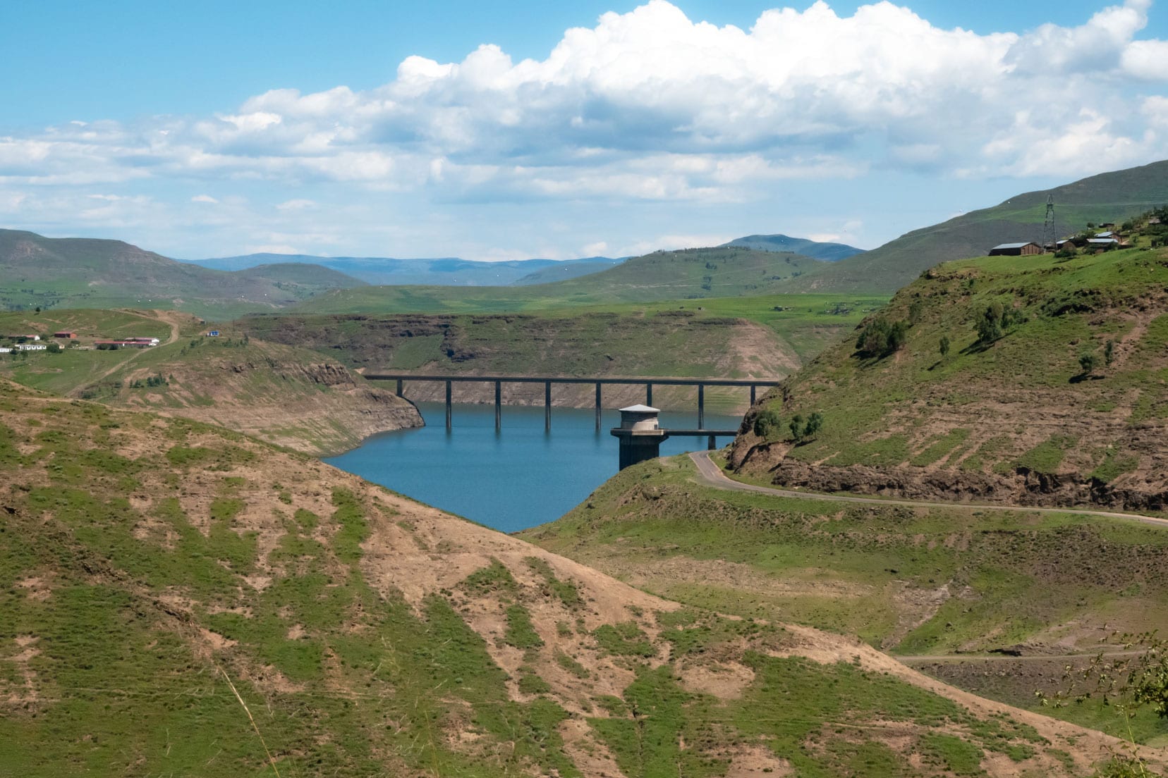
Katse Dam
A steep descent on the A25 from Mafika Pass soon brought Katse Dam into sight about 15km later. The road followed the dam’s banks for another 12km before crossing to the east side.
Driving for a further 1.6km will bring the turnoff to the Matsoku Tunnel Outlet 5 into view. Here, you have two options.
Either continue on the paved A25 for 36km to reach the Katse Dam Information Centre and Katse Lodge, or veer right onto the Matsoku Tunnel Outlet 5 gravel road for a scenic 22km drive, then re-join the A25 to the Katse Lodge.
We took the turn-off onto the gravel.
Quick Facts and History of Katse Dam.
It was constructed in the early 1990s and collects runoff water from the surrounding mountains, causing the Malibiamatso River to back up more than 30 kilometres. When full, the dam’s total surface area is 38.5 square kilometres, with the water piped to the Vaal Dam in Gauteng Province, South Africa.

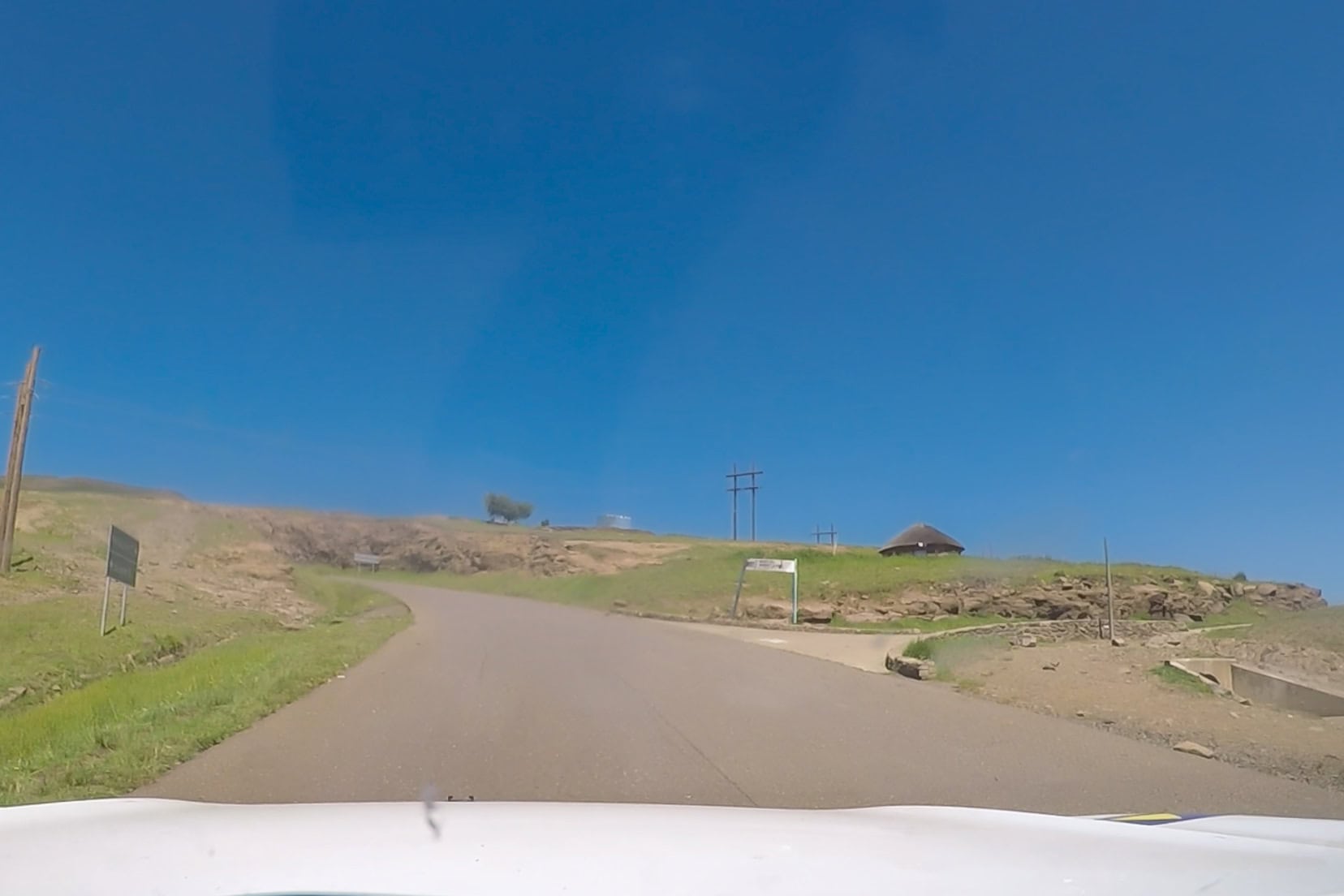
The gravel road was in reasonable condition, with many small streams crossing it. We kept our speed nice and slow and enjoyed the drive.
Making Friends
Beside each stream was a village. On the day we were there, it was a Sunday, and the kids were home from school. Our Hilux diesel engine must have sounded like a school bell as it drew the kids from everywhere.
They were smiling and waving, and of course, we stopped to say hello. Out came the chalk, stickers but it was the ‘bonbons’ that seemed to be the big hit.
When Shelley handed out the different-coloured chalk, the kids didn’t understand its purpose. It was only after she started to draw on some roadside stones that their faces lit up, and their big smiles gave away that they understood.
Soon, all the little hands were out for the coloured chalk.


As we stopped close to the villages, the adults outside their homes glanced at us casually, smiled, and we all waved. We have to say, though, it was just the best to see the true joy on those young faces.
It didn’t stop here, though. Driving over each rise, other villages came into view with a new crowd of smiling kids. Luckily, we had bought plenty to share.
Katse Lodge Camping: Katse Dam
After rejoining the sealed A25, we drove 7 km to the Katse Lodge Camping Area. To access the campsite within the fenced compound, stop at security and explain your visit. They will direct you to the Katse Lodge reception.
The lady at reception was friendly. After paying the camping fee, we were directed to a vacant house where we could camp in the backyard. There were hot water showers inside and an electricity point in the backyard.
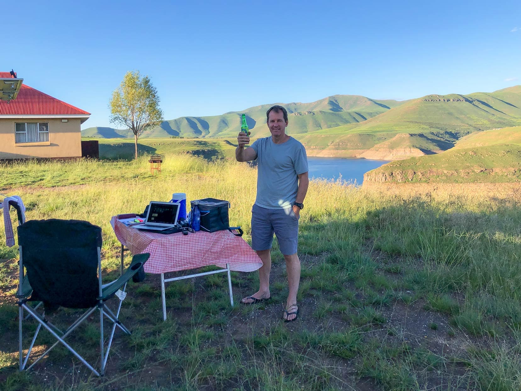
It was a great overnight stop. Quiet with lovely views over Katse Dam.

Day 2 Itinerary: Katse Dam Lesotho to Sani Pass Summit
This day’s drive took us roughly 8 hours.
Katse Dam ➝ Thaba-Tseka ➝ Mokhotlong Junction ➝ Sani Tops Backpackers Campsite
We had a leisurely start to the day, departing Katse Lodge campsite mid-morning. Our plan was to camp at the Sani Pass Lodge that night. I would have set off much earlier if I had known what lay ahead.
The drive on the A25 gravel road to Thaba-Tseka was 62km. The first 33km was easygoing, but the final 24 km was low-range first gear for a good part of the way due to deteriorating road conditions.

Driving over the sharp, rocky sections of the mountains ensures that your speed is kept safely down. We didn’t see any other vehicles or people.

After the village of Thaba-Tseka, the road conditions improved. The road followed the high mountain ridges and gave spectacular views over the Lesotho highlands. At Mejonang Pass, we stopped and spent some time in the open air, admiring the countryside and stretching our legs.
Sign of Life
There were now again some signs of humanity with pockets of villages close to the road. The gravel road was in good condition, and we could increase our speed.


To the Sani Tops Backpackers Campsite
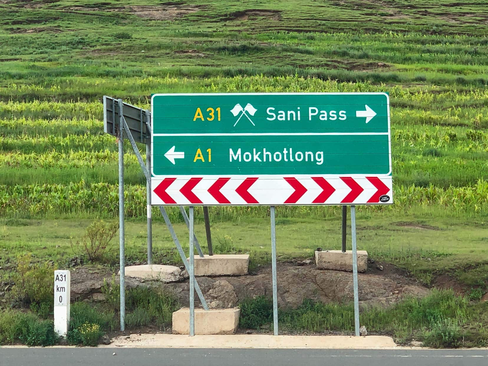
At the Mokhotlong junction, we turned right onto the A1. With 66km ahead to reach the Sani Lodge Backpackers, we selected 2WD and increased our speed. It had taken us 8 hours to reach this point.
This sealed section of road to the Sani Pass was in superb condition. The road winds through the mountains, offering magnificent views.
As fate would have it, our adventures had not yet ended for the day.
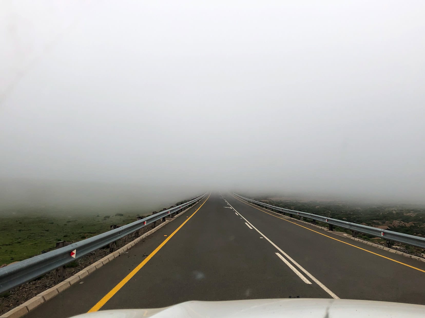
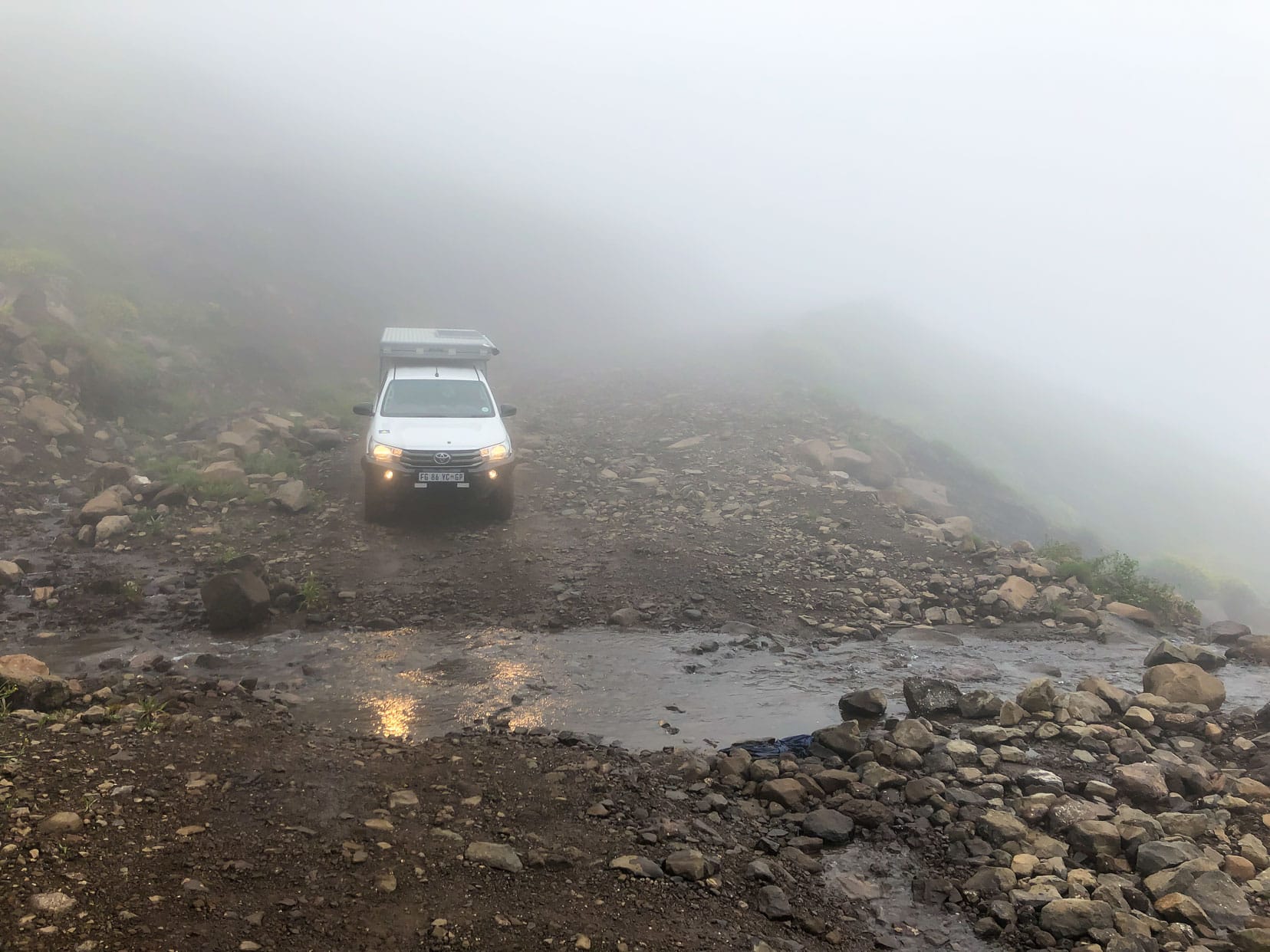
Unbeknownst to us, but common at this time of year, thick clouds and fog were rolling up and over the Sani Pass. Driving this last stretch to the Sani Pass campsite was done very slowly.

We passed the ‘Highest Point’ sign of Lesotho’s highest nearby mountain, Thabana Ntlenyana, which stands at an altitude of 3482m and claims the title of the highest peak in Africa south of Mt Kilimanjaro.
We couldn’t see the peak, and with the light quickly fading, we needed to push on. Visibility was now down to a few metres and both of us were fully focused on the road ahead.
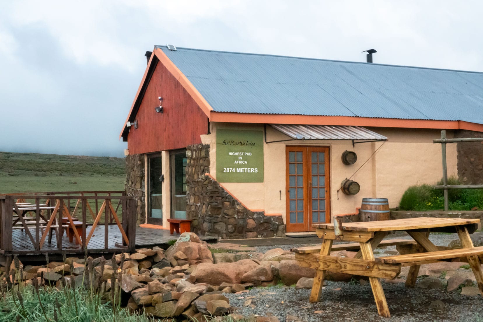
Just as it was going dark, we turned into the carpark of the Sani Mountain Lodge. It was a long day and we were determined to enjoy a drink at the Highest Pub in Africa, at the Sani Mountain Lodge.
We organised and paid for our campsite at the lodge. The fog was ridiculously thick, becoming temporarily lost. I had to ask Shelley to walk in front of the Hilux with a torch as visibility was under a metre.
Finding our campsite, we showered and quickly fell asleep; our vehicle was heavily shrouded in fog.


Day 3 Itinerary: Depart Lesotho for South Africa
Bye, Lesotho!
We awoke the next morning to find the fog had lifted, so we walked to the Sani Mountain Lodge to a lookout to check out the winding Sani Pass road and gauge the drive that lay ahead. It was still foggy down below, and as we watched, the fog thickened and quickly began to rise.
Thinking that this fog would continue to lift, we drove towards the start of the Sani Pass descent, parking off to the side. Little did we know that the fog would persist and only begin to thin a little at midday.
So we waited, unwilling to risk descending the Sani Pass in the fog. It was still pea soup, and we couldn’t see the Lesotho immigration office to have our passports stamped.
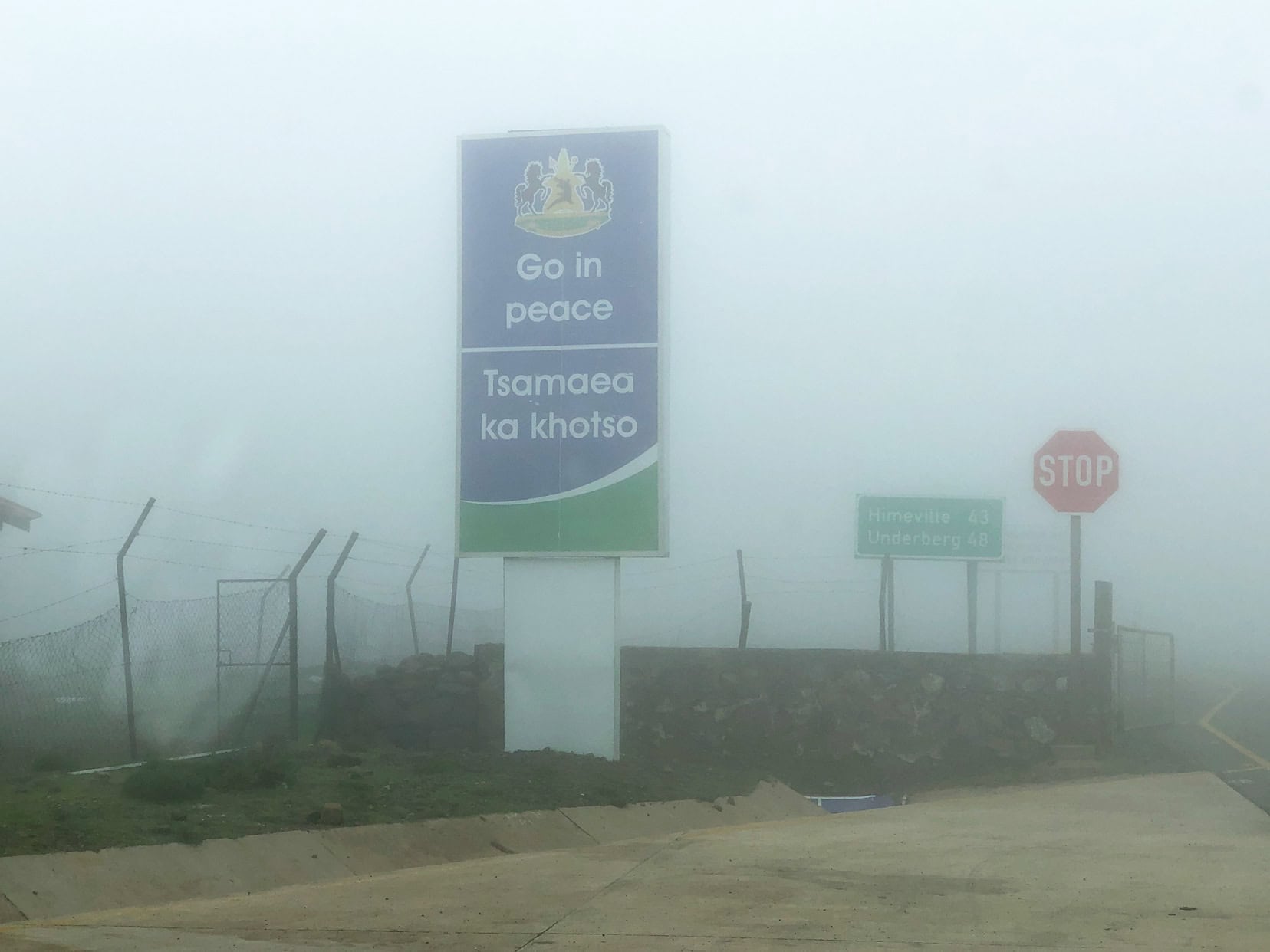
However, seeing a few locals returning to a taxi from a nearby building by the road, we soon sourced the right place. With passports stamped, we were ready to tackle the famous Sani Back to re-enter South Africa.
But that’s another story…
READ MORE: Driving the Iconic Sani Pass
Road Trip Lesotho with an Organised Tour
If you decide not to hire a 4×4 vehicle, then you can still enjoy Lesotho by booking an organised tour, like the one below:
Lesotho Campsites We Used On This Road Trip
As mentioned in this article, we stayed at two paid campsites. Both were absolutely fine with hot running water and working toilets which is all we needed.
The two campsites were:
- Katse Lodge, located at Katse Dam
- Sani Top Backpackers campsite, located at the Sani Pass summit.
Lesotho Road Trip … That’s a Wrap
This Lesotho road trip showcases the raw beauty and adventure of traversing the Roof of Africa. Whether you’re behind the wheel of a 4×4 or a standard car, you can enjoy the serene waters of Katse Dam and the country’s breathtaking views.
Every mile revealed something unforgettable in this Mountain Kingdom and brought us closer to the warm-hearted Basotho people, whose smiles added to our experience. Lesotho’s untamed wilderness is more than just a destination; it’s an adventure of a lifetime, accessible to all.
As we continue exploring, Lesotho remains a highlight, reminding us that the best adventures are often found on the roads less travelled.
Are you ready to experience Lesotho? Have you driven the Sani Pass or enjoyed a drink at the highest pub in Africa? We’d love to hear from you.
Pin and Save for Later
Read more:
- Kruger: Self-drive Kruger National Park
- Johannesburg: Rhino and Lion Nature Reserve – Safari in the Suburbs
- Photographing Wildlife: Best Safari Photo Tips
- Living in the SA Bush: An Australian Take on Life in the South African Bush
- Prince Albert, Karoo: Things to do in Prince Albert, Karoo, Western Cape
Planning Your Travels?
These are the travel resources we recommend and use when planning our trips.
- 🚘 Car Hire: We use DiscoverCars.com
- Motorhome/Campervan Rental: We highly recommend the Motorhome Republic
- 🪪 Order your International Driver’s Licence online here
- 🛏 Book Accommodation: We use Booking.com to find accommodation that suits our budget
- 🐶 Pet Sitting/Pet Sitters: Check Out TrustedHousesitters here (Use our Discount code: LIFEJOURNEY25 for 25% off. )
- Activities and Experiences: Get Your Guide and Viator
- Travel Insurance: Safetywing or World Nomads
- 🥾 Travel Gear and Accessories: Check out our top picks here — Lifejourney4two page on Amazon
For a more thorough list, visit our Travel Resources page here.
🇱🇸🇱🇸 Beautiful Mountain Kingdom 🇱🇸🇱🇸
It is indeed Tsebiso 🙂
Thanks for visiting my beautiful country. The true kingdom in the sky😍
Hi Jane, it was a fantastic trip and we would love to go back and spend more time there:) xxx
Lesotho a harmonious place ever
It’s a beautiful place to visit Emily that’s for sure.
We are called and written as BASOTHO. Thank you for visiting Lesotho.
Hi Khahliso – thanks for letting me know. I’ve made the correction. We sure enjoyed Lesotho!
Thanks, I guess I’ll have to use the A1 butha-buthe to Sani to and fro. Was hoping to ride in one route and out another
Good luck on your ride. If you can, let me know how it all went. Go well!
Thanks for sharing your trip info. I’ve done similar trip, entering from the Sani pass and exiting through Maseru via A1. I’m planning another trip to Sani on a motorcycle, riding from the Mogale dam side (A3). I just need to understand exactly which parts of the A3 are rough as my bike is not an off-roader. I might have to consider alternative route if it won’t be feasible. Thanks
Hi Nathan, A bike trip sounds awesome. Riding east on the A3, you reach the junction where the A25 goes north and Thaba-Tseka lies more or less south. It is this southern route past Thaba-Tseka where we encountered rough terrain (1st gear low range) with sharp, jagged rocks. This rough ground continued past Mohlanapeng and started improving after the first crossing of the Orange River (approximately 20 km). Guess you could always take a look and if it doesn’t look do-able you could turn back. Your advantage is you won’t be as weighty as our 4wd. Enjoy the trip!