
Planning a trip to the Lofoten Islands in Norway? You won’t want to miss the Ryten Lofoten hike, a standout among the stunning landscapes made famous by the movie Frozen.
If you’re seeking an unforgettable hiking experience that combines breathtaking fjord views, challenging trails, and the pristine beauty of Kvalvika Beach, then the Ryten hike needs to be at the top of your list.
As Lofoten hikes go, this one, you’ll be happy to hear, is a hike that ticks all the boxes and ranks as one of our best hikes in Norway.
Having lived in Norway for years, this was one hike that we especially wanted to conquer during our Lofoten road trip.

🥜 Ryten Lofoten Hike: In a Nutshell 🥜
- 🥾 Total Hiking Time (Round Trip): 3.5 to 5.5 hours. We hiked uphill for 1 hour 45 minutes and took 1 hour 30 minutes for the downhill at a steady pace.
- ⬆️ Elevation Gain: 680 metres.
- 📏 Hiking Distance (Round Trip): 8.7 kilometres.
- 😰 Difficulty Rating: Medium (blue), according to the Norwegian Tourist Association. It is suitable for anyone with basic fitness and hiking skills.
- ⏰ Best Time to Hike: May to September. Snow in colder months can make the trail challenging.
- 📍Trailhead Location: Start at the dedicated Ryten hike parking area near Fredvang.
- 🅿️ Parking Information: Cash-only parking costs 100Kr (approximately 10 Euro) for a day’s parking. Ensure you pay before starting your hike.
- 🚻 Facilities: No restrooms along the trail. Bring plenty of water.
- 〽️ Trail Conditions: Parts of the trail can be boggy, but wooden planks help in the worst spots.
- 🦺 Safety Tips: Check the weather using the YR.no app. Wear appropriate hiking shoes and pack waterproof clothing if needed.
- 🎒 Recommended Gear: Hiking footwear, a small backpack to carry food, water and a camera.
- 🚶🏻♂️➡️Alternative Routes: At Forsvatnet Lake, you can descend to Kvalvika Beach or continue to the Ryten summit. Add 3 hours for the return trip back to the lake.
Highlights:
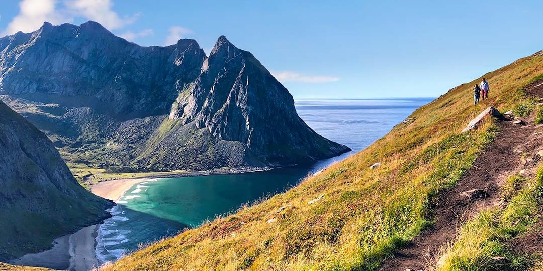
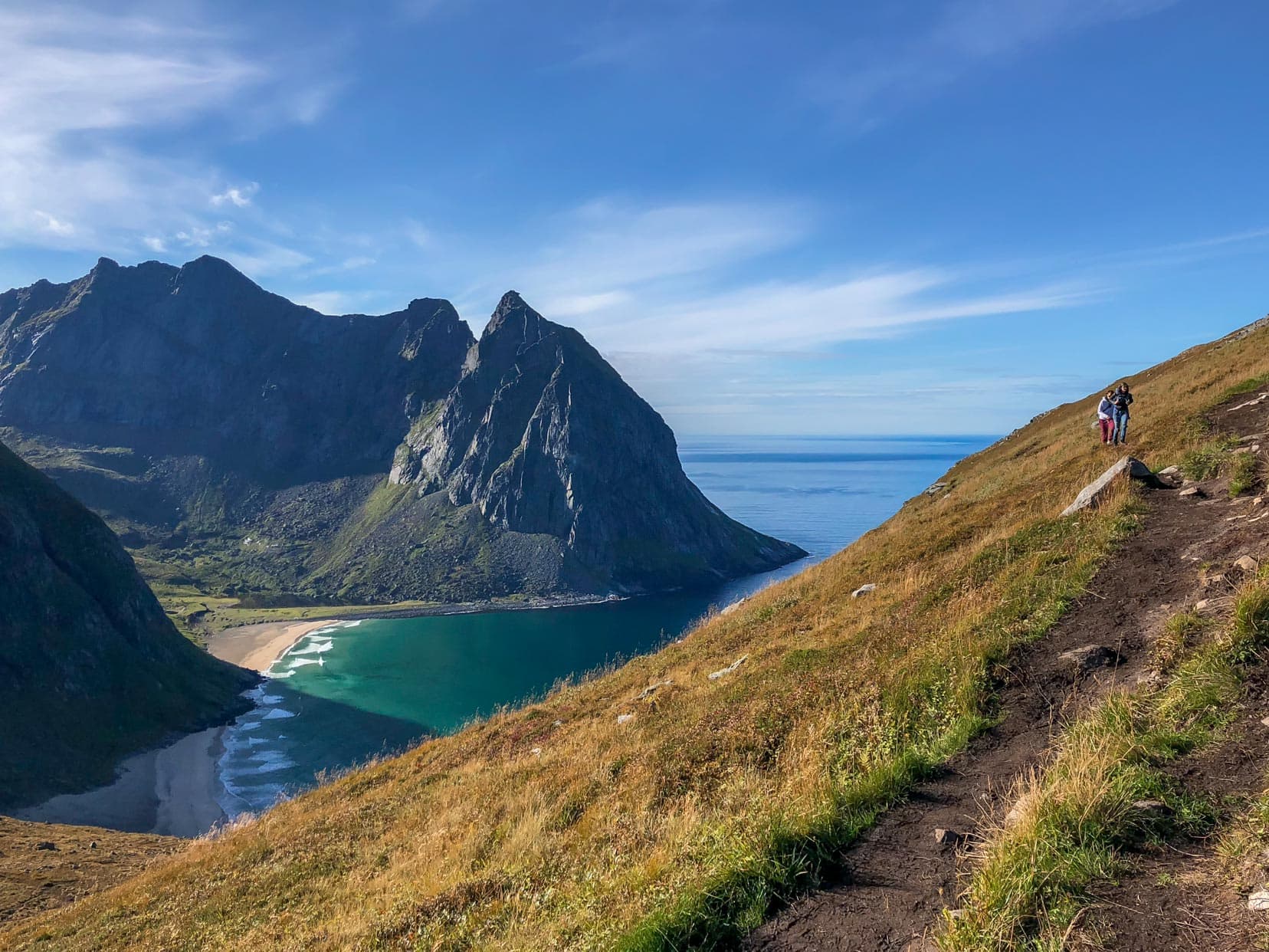
- 🏔️ Stunning Views: Enjoy the beauty of Kvalvika Beach, stunning mountain peaks, gorgeous bays, islets, and rocky outcrops. The views are truly spectacular!
Viewing and Photography Tip:
Time your climb carefully. We hiked in September, arriving at the top of Ryten Mountain mid-morning. When looking east towards Kvalvika Beach, the sun was straight in our eyes. It wasn’t the best and was even tougher taking photos without the sun’s glare.
Map: Ryten Lofoten Hike
Planning a Trip to Norway?
- 🚗 Hiring a car? We recommend getting a quote from DiscoverCars
- 🚐 Hiring a campervan? We recommend Motorhome Republic
- ⛑ Arranged your travel insurance? Compare quotes from World Nomads & Safetywing
- 🪪 Order your International Driver’s Licence online here
- 🏩 Booked your accommodation? We use Booking.com to find the best deals
- 🐾 Is someone pet-sitting for you? 🐾 We use and love TrustedHousesitters
- (Get 25% off at checkout for new memberships with our discount code: LIFEJOURNEY25)
Ryten Hike Teaser Video
Finding the Trailhead: Starting Your Ryten Lofoten Hike
Ryten is a mountain on the northern part of the island of Moskensoya, Lofoten in northern Norway.
To get to Ryten, head towards the island’s northern town, Fredvang. There are two parking options, with option 1 providing amenities and services. Option 2 is parking only. Parking
Parking Option 1: Innersand Parking (recommended)
- From Fredvang, follow the FV808 road north for 300m, turn west onto the FV806.
- Continue 1.9km then turn left at the T-junction.
- Parking is 300m ahead.
- Cost: NOK100 for day parking plus an extra NOK100 for overnight parking.
- Toilets, fresh drinking water, washing facilities and charging stations (for phones, camera batteries, etc.) are available here.
- During summer, snacks, coffee and souvenirs are for sale.
- Closer to the trailhead than parking option 2.
Parking Option 2: Farm Parking (where we parked)
- From Fredvang, follow the FV808 road north for 300m, then turn west onto the FV806. Continue for about 1 kilometre.
- You’ll reach a road named ‘Strandveien’. Turn left into a fenced, dedicated parking area.
- The parking fee is cash-only and costs NOK100 for the day.
- The landowner, who lives nearby, monitored new arrivals and ensured that we had paid before starting our hike.

Top Tips for a Successful Ryten Hike
- Check the Weather: Get the latest weather updates using the free app YR.no from the Norwegian Meteorological Institute.
- Use Offline Maps: Download the free app maps.me for offline use. It includes hiking trails and allows you to log your route for later reference.
- Plan Ahead: Plan your route and pack plenty of drinking water.
- Wear Proper Gear: Wear hiking shoes and bring waterproof clothing if the weather is uncertain.
Step-by-Step Guide to the Ryten Hike (From Farm Parking)
Leaving the parking, walk about 100m north along FV806. Here, you will see a path through the farmer’s land. Follow this for about 600m to reach a walking trail.
Turn left and continue on a single-lane track for 500m, marking the official trailhead.
The trail climbs gently and becomes more of a track. There are boggy spots, but luckily, some well-placed wooden planks reduce the risk of ploughing through the mud.


Reaching the top of the first line of hills, it flattens out for a time. Twin lakes come into view, the largest of the two named Einangsvatnet.
This is a great spot for photos, with extensive views down into the valley and out to Sandbotnen Bay. Here at Einangsvatnet, you can probably consider this to be about one-third of the upward part of the hike complete.

The ascent starts to get tougher, with the incline steadily increasing as you pass over a series of small rises.

By now, you’ve climbed high enough to see above the closest hills to the distant mountain ranges. There are fantastic panoramic views.
It’s a good time to get the camera out and rest those legs. You are about two-thirds of the way up now.

Taking to the trail again, a further 800-odd metres will bring you to Forsvatnet, a lake with pristine waters.
This is a decision point.
Either take the path to the ascending right trial to Ryten or follow the descending left trail to Kvalvika beach. From here, it’s a 3-hour return hike to Kvalvika Beach and a 1.5-hour return hike to Ryten Peak.
With our eye on the prize, we ascend to even steeper ground. Don’t despair, this is the last sharp incline to the top. Kvalvika beach views await.
It’s a bit of a thigh burner but those views soon have you forgetting about any feelings of discomfort. A bit of grit and determination will see you through;)

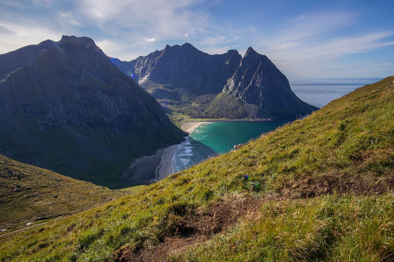
Unveiling the Stunning Views of Kvalvika Beach
Most hikers on the Ryten trail aim for the famous viewpoint, a rocky outcrop that mimics Trolltunga—a mini version. No way we were going to miss this.
Here, you can overlook Kvalvika Beach and grab some fabulous photographs.

You may have seen photos from this epic spot on the rocky outcrop at the top of the Ryten hike that overlooks Kvalvika Beach. Am I risking life and limb here?
Well, the image I must admit is quite deceptive and no, there’s little risk being taken here. There’s no sheer drop and it’s much safer than it looks.
Look at the image below. The guy standing on the rock is at the famous viewpoint, but you can see that the rocky plateau does not have the plummeting, dangerous cliff face that it seems to have.


We walked downhill about 100m to have better views of Kvalvika Beach, but we were a little confused – we saw two beaches. We didn’t read about there being two beaches.
But it’s all the same beach. On a rising tide, the headland divides the beach into two, offering great photo opportunities.


Navigating the Descent: Ryten Hike Return Trip
As with many mountain hikes, the descent can often be as tough as the ascent. This hike was no different in that aspect, especially the first section from the viewpoint.
It’s quite steep and slippery because it is a well-trodden path that has turned somewhat muddy. Slow and steady is the name of the game here.
Even though the trail requires careful negotiation, there are plenty of amazing views that deserve time for enjoyment.
With the sun’s shifting, the landscape was revealed in a different light. Could it be even more spectacular than before? Yes, it could.
There was a lot more stop/start on the descent; simply to enjoy this beautiful scenery surrounding us.

Best Places to Stay Near Ryten Lofoten
We stayed in Reine at the Lofoten B&B, which is 25 kilometres from Fredvang or roughly a 30-minute drive. It is a great location for an overnight stop.
Do you want to stay on Ryten’s doorstep?
The trailhead is just 900m away. Heloíse`s accommodation gets fantastic reviews, see for yourself.
Heloíse`s Accommodation
8.6/10 Fabulous
Best Reviewed and Lowest Price
✔️ Location
✔️ Free Wifi
FAQs – Ryten Hike
1. Would this be a suitable hike for families?
Yes, most definitely. The trails to Ryten and Kvalvika Beach are suitable for families, and the Ryten climb is also suitable for children and families.
2. Can I see the Northern Lights in September in Lofoten?
Yes … and we did. September to April are the best months to view the Northern Lights in Lofoten; however, weather plays a major part in governing whether the lights will be visible or not, with winter weather offering clouds and rain.
3. Do I need any special hiking gear to hike Ryten Lofoten and Kvalvika Beach?
No, however, hiking footwear and a small backpack to carry food and water are recommended.
4. Can you use a drone in the Kvalvika and Ryten areas?
No, drone use is prohibited in the Ryten and Kvalvika areas as they fall within Lofotodden National Park.
5. I have a dog; can I bring him to Ryten and Kvalvika Beach?
Yes, but under strict conditions. Your dog must be on a leash from April 1st to November 15th.
6. How much time do I need to hike Ryten?
Depending on time and fitness levels, 3 to 5 hours would be the right amount of time to hike Ryten, so you could set aside a morning or an afternoon.
7. How do I get to Ryten?
Go to the nearest town, Fredvang, and follow the FV806 north. There are two parking places. One is a farm with no facilities, and the other has toilets, water, and food (see map). The Ryten trailhead is a short walk from either of the parking places.

Understanding Hiking Levels in Norway
Norway classifies its walks and hikes depending on the difficulty as follows:
- Easy (Green) – Novice Hikers/ No experience necessary
- Medium (Blue) – Intermediate with some hiking experience /average fitness level
- Demanding (red) – Experienced walkers/high fitness level well equipped with good hiking boots/ basic navigation skills /map and compass.
- Expert (Black) – Longer and more technical hikes /Experienced hikers/ high fitness level well equipped with good hiking boots/ basic navigation skills/map and compass
Ryten Hike … That’s a Wrap
If you’ve made it to Lofoten, we strongly recommend adding the Ryten hike to your Norway itinerary. It offers spectacular views, the trailhead is conveniently close to parking and you can hike it in half a day.
The hike can be done in the morning or afternoon, so it won’t compromise a tight schedule.
Remember, September is the month when the Northern Lights in Lofoten begin their dance—keep your eyes open at sundown to witness one of nature’s miracles.
We hope you enjoy the Ryten Lofoten hike as much as we did!
If you enjoy epic hikes, Dronningruta Hike—The Queen’s Route is another one in Lofoten, Norway, that you should seriously consider.
Do you have a particularly memorable hike in Norway? Any favourite hikes? We’d love to hear about them.
DISCOVER MORE OF NORWAY
NORTHERN LIGHTS ADVENTURE: Catch the awe-inspiring Northern Lights with our guide to the Northern Lights in the Lofoten Islands.
MUST-TRY HIKES: Dive into our best hikes in Norway guide featuring must-try trails, including Kjeragbolten, Himakånå, and the majestic Torghatten.
VIKING HERITAGE AND HISTORY: Explore the rich Viking history of Norway at Avaldsnes: Norway’s Viking Kings, discover the quaint charm of Skudeneshavn, and uncover the street art of Utsira.
EPIC NORWEGIAN ROAD TRIPS: Experience stunning vistas and cultural landmarks on our Lofoten road trip, explore iconic Norway Stave Churches, and journey from Bergen to Trondheim and further to Bodø.
Pin and Save for later
Planning Your Travels?
These are the travel resources we recommend and use when planning our trips.
- 🚘 Car Hire: We use DiscoverCars.com
- Motorhome/Campervan Rental: We highly recommend the Motorhome Republic
- 🪪 Order your International Driver’s Licence online here
- 🛏 Book Accommodation: We use Booking.com to find accommodation that suits our budget
- 🐶 Pet Sitting/Pet Sitters: Check Out TrustedHousesitters here (Use our Discount code: LIFEJOURNEY25 for 25% off. )
- Activities and Experiences: Get Your Guide and Viator
- Travel Insurance: Safetywing or World Nomads
- 🥾 Travel Gear and Accessories: Check out our top picks here — Lifejourney4two page on Amazon
For a more thorough list, visit our Travel Resources page here.
Thanks for your info. We are from Thailand and will be in Lofoten between April 11-15. Can we do the Ryten Hike then?
Thanks
Vitharon
Hi Viatharon – No, we wouldn’t recommend doing it in April – It will likely still be covered in snow and without the proper equipment it would be dangerous. Also hard to see the trail and on top of that probably an avalanche risk too.
Enjoy your time in Lofoten though – it will be pretty in the snow:)